|
||

|

|
|

|
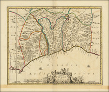
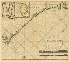
Detailed Map of the Gold Coast From a Celebrated Voyage Collection
Finely-wrought map of the coast of Ghana, from the voyage account of Jean Barbot in the Churchill brothers’ renowned voyage collection, published in London in 1732.
The maps of the Gold Coast in this collection, engraved by Johannes Kip, offer some of the most detailed views of the slave forts ever published.
The main map shows the Ghana coast, also known as the Gold Coast, from the Volta River in the east to the Rio da Costa, or Tano River. Dotted lines suggest political divisions but, in reality, the Europeans knew relatively little about the interior of the region. Mountain ranges frame the land, as do rivers that extend in from the sea. The coast line is thickly covered with villages and forts. In the ocean, a ship sails along, suggesting the importance of this maritime region for commerce, especially the slave trade.
Tucked into the corner of the main map is an inset of the coastline of Mina and Cabo Corso. Above this is an inset view of Cape St. Appollonia, which was named by the Portuguese and fortified by the Swedish. Later, in 1691, the British built a trading post there and by the late-eighteenth century it had expanded into a slave fort.
Elmina Castle, the Gold Coast, and the slave trade
Mina, better known as Elmina Castle, was the first of roughly thirty European forts clustered along the Gold Coast. It is the oldest European building south of the Sahara. Built by the Portuguese in 1482, the fort was also known as St. George’s Castle. Jean Barbot, who wrote the account from which this map derived, visited Elmina in 1682. He wrote:
This castle has justly become famous for beauty and strength, having no equal on all the coasts of Guinea. Built square with very high walls of dark brown stone so very firm that it may be said to be cannon-proof. On the land side, it has two canals always furnished with rain or fresh water sufficient for the use of the garrison and ships-canals cut in the rock by the Portuguese (by blowing up the rock little by little with gun powder). The warehouses either for goods or provisions are very largely and stately always well furnished.
By the time Barbot visited, Elmina had been captured by the Dutch. While the Portuguese had used the fort to ferry gold, textiles, and some slaves to Atlantic ships, bound for the Americas, the Dutch accelerated this process. Roughly 30,000 slaves a year were kept at Elmina before being forcefully removed to the Caribbean and Brazil.
The Dutch constructed the nearby Fort Coenraadsburg [here Conradsburgh] to further defend Elmina. Additionally, the Swedes had built Cape Castle [here Cabo Corso] in the 1650s. It was overtaken by the Danish, Dutch, and English by the 1660s. The English shifted its focus from trading in gold and textiles to human lives.
Originally fortified to defend the gold trade, the Gold Coast eventually became focused almost exclusively on the exportation of enslaved peoples. By the time this map was made in the early-eighteenth century, the British, Dutch, and other Europeans were heavily involved with local leaders to supply forced labor to the plantations of the Americas.
Jean Barbot
This map derived from the descriptions provided by Jean Barbot (1655-1712), a Frenchman. The French had begun to contest Portuguese trading on the Gold Coast in the 1530s; Barbot worked for the Compagnie du Sénégal. He went to Africa twice between 1678 and 1682, when he visited many of the forts along the coast.
A Huguenot, Barbot had to flee France after the 1685 Edict of Nantes, settling in England. He had finished a draft of his voyage account by 1688, but failed to find a publisher for the work. Instead, it only appeared in print in 1732, as part of the Churchill’s expanded voyage collection.
Barbot has long been used as a primary source of information about the Gold Coast. In recent decades, however, his account has been called into question by scholars. Comparisons of his work with other contemporary sources reveal that he relied on other African travelers as well, especially the Dutchman Olfert Dapper.
The Churchills’ voyage collection
The Churchill brothers, Awnsham (1658-1728) and John (ca. 1663-ca. 1714), were publishers in London who catered to an affluent clientele, and they were from a prominent family themselves. A distant relative was John Churchill, the Duke of Marlborough. Two of their older brothers, Joshua and William, served as Members of Parliament. Awnsham also was elected an MP for Dorcester in the first years of the eighteenth century.
In 1704, they released the first edition of one of their most successful works, A collection of voyages and travels: some now first printed from original manuscripts, others now first published in English. The collection consisted of four volumes of voyages and travel accounts derived from primary sources in English, French, Dutch, Italian, Spanish, and German, a feat not seen since Hakluyt’s work over a century earlier.
The Churchill brothers are perhaps best-known today as the publisher of the works of John Locke. Awnsham supported religious tolerance and moderation for nonconformists, stances that would have appealed to Locke. Locke is supposed to have written the introductory discourse which opens the voyage collection.
This map appeared in the 1732 expanded edition, which extended the collection to six volumes. Barbot’s Description of the Coasts of North and South Guinea featured in the fifth volume. A further edition of eight volumes was issued in 1752.
The collection was widely respected and considered one of the most prestigious examples of the genre in the eighteenth century. The maps and illustrations from the collection are relatively scarce on the market, especially given how important the publication was when it debuted.
Johannes Kip (1653-1722) was a topographical engraver. Born in the Netherlands, he had immigrated to England by 1690. His most famous work are the engravings of country houses in Britannia Illustrata (1707), which he produced with Leonard Knyff. He also contributed to the 1732 expanded edition of the Churchill brothers voyage collection.