|
||

|

|
|

|
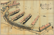
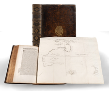
The First Map of Adelaide
Rare cadastral map of the area around Adelaide, published by John Arrowsmith.
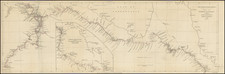
The map illustrates Adelaide and the region surrounding, centered on the 'City of Adelaide', covering an area from Port Adelaide in the north down to present day Brighton in the south The outlying area is divided into 443 blocks of land, the smaller lots at 80 acres each with the larger lots at 134 acres each. Lots sold are shown in color, with the names of the owners shown. Trigonometrical survey stations are marked with dots enclosed in open circles.
The first state of the map includes Arrowsmith's address at 35 Essex Street. In Adelaide the map shows the roads, canals, schools, store, barracks, cemetery and hospital. There is an indication to prospective buyers of areas where the streams dry up in summer. The relief is shown by hachures and hill shading and vegetation is indicated. Tributaries of the River Torrens are shown.
The map would later be re-issued in First Report from the Select Committee on South Australia (British Parliamentary Papers) in 1841.
As noted by Prescott:
The creation of the Province of South Australia took place in 1836 after many years of negotiation with the Colonial Office, the first proposals having been made by Edward Wakefield as early as 1829, and other proposals made later by the National Colonization Society and the South Australian Land Company. Eventually the South Australian Association's members managed to persuade Parliament to pass the South Australian Act. Authority for the new province was to be shared between the Colonial Office and the Colonization Commission. The surveying and allotment of land was achieved by March 1837 but the first ballot for country sections was delayed until May 1838. This is the subject matter of Arrowsmith's map of Adelaide which shows the allotment numbers and names of buyers.
This map was first issued in February 1839 and again in February 1840. Both these states are also found with additional parliamentary imprints in Parliamentary reports of one kind or another. It is also found at the end of Robert Kearsley Dawsonís Report on surveying. The map was issued over a period of just over two years and is found in eight states. . . .
Adelaide
The South Australia colony was founded in 1836.The first surveys were supervised by Colonel William Light, surveyor general of the colony. 150,000 acres were surveyed around Adelaide using a strict trigonometric methodology, before the directors of the colony instructed a switch to faster rectangular running surveys.
The first governor of the new colony was Captain John Hindmarsh who arrived December 28, 1838. In 1840 Adelaide was incorporated (the first incorporated city in Australia).
In 1840 Adelaide had a population of over 2,000. By 1850 Adelaide had a population of over 14,000. In 1900 Adelaide had a population of 162,000.
Rarity
This is the second example of the map we have ever seen. We found no auction or dealer records for the map.
The Arrowsmiths were a cartographic dynasty which operated from the late-eighteenth century to the mid-nineteenth. The family business was founded by Aaron Arrowsmith (1750-1823), who was renowned for carefully prepared and meticulously updated maps, globes, and charts. He created many maps that covered multiple sheets and which were massive in total size. His spare yet exacting style was recognized around the world and mapmakers from other countries, especially the young country of the United States, sought his maps and charts as exemplars for their own work.
Aaron Arrowsmith was born in County Durham in 1750. He came to London for work around 1770, where he found employment as a surveyor for the city’s mapmakers. By 1790, he had set up his own shop which specialized in general charts. Arrowsmith had five premises in his career, most of which were located on or near Soho Square, a neighborhood the led him to rub shoulders with the likes of Joseph Banks, the naturalist, and Matthew Flinders, the hydrographer.
Through his business ties and employment at the Hydrographic Office, Arrowsmith made other important relationships with Alexander Dalrymple, the Hudson’s Bay Company, and others entities. In 1810 he became Hydrographer to the Prince of Wales and, in 1820, Hydrographer to the King.
Aaron Arrowsmith died in 1823, whereby the business and title of Hydrographer to the King passed to his sons, Aaron and Samuel, and, later, his nephew, John. Aaron Jr. (1802-1854) was a founder member of the Royal Geographical Society (RGS) and left the family business in 1832; instead, he enrolled at Oxford to study to become a minister. Samuel (1805-1839) joined Aaron as a partner in the business and they traded together until Aaron left for the ministry. Samuel died at age 34 in 1839; his brother presided over his funeral. The remaining stock and copper plates were bought at auction by John Arrowsmith, their cousin.
John (1790-1873) operated his own independent business after his uncle, Aaron Arrowsmith Sr., died. After 1839, John moved into the Soho premises of his uncle and cousins. John enjoyed considerable recognition in the geography and exploration community. Like Aaron Jr., John was a founder member of the RGS and would serve as its unofficial cartographer for 43 years. Several geographical features in Australia and Canada are named after him. He carried the title Hydrographer to Queen Victoria. He died in 1873 and the majority of his stock was eventually bought by Edward Stanford, who co-founded Stanford’s map shop, which is still open in Covent Garden, London today.