|
||

|

|
|

|
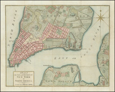
Fine map of Manhattan, Long Island, and nearby counties Putnam, Rockland, and Westchester.
Neighborhoods are delineated, and towns, railroads, canals, post offices, wagon roads, harbors, and more are located. Bordering parts of New Jersey, Pennsylvania, and Connecticut are visible as well.
At the bottom of the map is a "time indicator" comparing the time in Albany with the times in 29 nearby towns based upon the sun. Time zones were not created until 1883, when the evolving transportation and communication map cover networks required a unified time-keeping system.
Asher & Adams was a New York publishing firm known for their atlases. Notably, their maps were some of the first to prominently exhibit railroad lines, even if this meant a slight reduction in topographical detail. They specialized especially in state and county maps of the United States.
![(Pocket Map) Colton's New York City, Brooklyn, Jersey City, Hoboken Etc [G. Woolworth Colton's New York City Jersey City, Hoboken, Brooklyn]](https://storage.googleapis.com/raremaps/img/small/85405.jpg)
![[Last of the Mohicans / New York] Carte dressee pour la lecture du Dernier des Mohicans Roman de J. Fenimore Cooper](https://storage.googleapis.com/raremaps/img/small/86045.jpg)