|
||

|

|
|

|
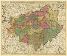
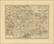
Decorative map of the Archbishoprick of Cologne, published by Blaeu in Amsterdam
Oriented with west at the top, the map shows Coblentz, Cologne, Wessel, Kempen, Dortmund and the course of the Rhine.
The map shows Coloniensis Archiepiscopatus, or the Archbishopric of Cologne, in the first half of the 17th century, against the backdrop of the broader European religious and political turmoil of the era, particularly the Thirty Years' War (1618-1648). In the early 17th century, the Archbishopric of Cologne, a significant ecclesiastical principality within the Holy Roman Empire, was under the rule of Ferdinand of Bavaria. Ferdinand, who became the Archbishop of Cologne in 1612, was a member of the Wittelsbach dynasty and a staunch Catholic. His accession coincided with a period of increasing Catholic resurgence during the Counter-Reformation, a movement aimed at countering the spread of Protestantism in Europe.
The Thirty Years' War, which began in 1618, dramatically influenced the political landscape of the Archbishopric of Cologne. The war, initially triggered by religious conflicts within the Holy Roman Empire, eventually evolved into a broader continental struggle, involving major European powers like France, Spain, Sweden, and the Dutch Republic. The Archbishopric, under Ferdinand's leadership, aligned with the Catholic League, a coalition of Catholic states within the Empire formed to counter the Protestant Union.
A major event in the decades before the map was the Battle of White Mountain in 1620, where the Catholic forces, including those from Cologne, decisively defeated the Bohemian Protestant rebels. This victory consolidated the Habsburg power in Central Europe and reinforced Catholic dominance. Throughout the 1620s and 1630s, the Archbishopric of Cologne continued to be influenced by the ebbs and flows of the Thirty Years' War. The Peace of Westphalia in 1648, which ended the war, had significant implications for the region. This series of treaties, among other things, reaffirmed the principle of cuius regio, eius religio (whose realm, his religion), allowing the rulers of the Holy Roman Empire's states, including the Archbishopric of Cologne, to determine their territories' official religion.
Willem Janszoon Blaeu (1571-1638) was a prominent Dutch geographer and publisher. Born the son of a herring merchant, Blaeu chose not fish but mathematics and astronomy for his focus. He studied with the famous Danish astronomer Tycho Brahe, with whom he honed his instrument and globe making skills. Blaeu set up shop in Amsterdam, where he sold instruments and globes, published maps, and edited the works of intellectuals like Descartes and Hugo Grotius. In 1635, he released his atlas, Theatrum Orbis Terrarum, sive, Atlas novus.
Willem died in 1638. He had two sons, Cornelis (1610-1648) and Joan (1596-1673). Joan trained as a lawyer, but joined his father’s business rather than practice. After his father’s death, the brothers took over their father’s shop and Joan took on his work as hydrographer to the Dutch East India Company. Later in life, Joan would modify and greatly expand his father’s Atlas novus, eventually releasing his masterpiece, the Atlas maior, between 1662 and 1672.
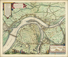
![[Course of the Rhine River] Corso del Reno Parte Septentrio [and] Corso del Reno Parte Meridionale . . . 1690](https://storage.googleapis.com/raremaps/img/small/73095.jpg)