|
||

|

|
|

|
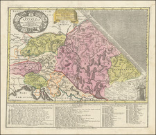
Detailed map of the ethnic make up of the the region between Istria and Herzegovina, pubished by Petermann in 1915.
The title shows the "The Latinity of the Adriatic coast of Austria-Hungary," including the following regions.
- Serbo-Croatians in the majority.
- Italians living among the local population.
- Civilian population in 1900 including Serbo-Croatians, Slovenians, Italians, Romanians and Germans.
August Heinrich Petermann (1822-1878) is a renowned German cartographer of the nineteenth century. Petermann studied cartography at the Geographical Art-School in Potsdam before traveling to Edinburgh to work with Dr. A. Keith Johnston on an English edition of Berghaus’ Physical Atlas. Two years later he moved to London, where he made maps and advised exploratory expeditions as they set off to explore the interior of Africa and the Arctic.
In 1854, Petermann returned to Germany to be Director of the Geographical Institute of Justus Perthes in Gotha. There, he was the editor of the Geographische Mittheilungen and Stieler’s Handatlas. The Royal Geographical Society of London awarded him their Gold Medal in 1860. He continued his interest in exploration in Germany, fundraising for the German Exploring Expeditions of 1868 and 1869-70, which sought an open Arctic sea. Tragically, he committed suicide in 1878.
![(Italy and Austria) Carta geografica statistica postale dell’I.R. Monarchia Austriaca e dell’Italia [Statistical postal geographic map of the Imperial Royal Austrian Monarchy and of Italy]](https://storage.googleapis.com/raremaps/img/small/94038.jpg)
![[ Croatia / Bosnia ] Der Sudliche Theil des Koenigreichs Dalmatien mit der Republik Ragusa](https://storage.googleapis.com/raremaps/img/small/103278.jpg)