


|
||

|

|
|

|
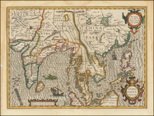
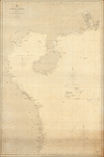
Striking Hondius Map of Southeast Asia
Fine example of Hondius' map of China and Southeast Asia, from a French edition of the Mercator-Hondius Atlas.
Extending from India to the coasts of Southern China with the Pearl River Estuary, Canton and Formosa, it also includes all of the Malay Peninsula and Indochina, northern Borneo, and the Philippines.
One of the most interesting and unusual features of the Southern Malay peninsula is its dissection in two, the southern part becoming an island just south of Malacca where it is separated from the rest of the peninsula by a northeasterly channel. Another important feature is the mythical Lake Chiamay, here written as Chiamai, which gives rise to five rivers.
The decorative detail includes a large sea monster, a European ship and an oriental junk. It also has the characteristic scrollwork title and scale cartouches of the Mercator-Hondius Atlas.
One of the finest early Dutch maps of the region, it was first published in 1606 as one of the 37 new maps engraved for Jodocus Hondius' expanded edition of the Mercator Atlas.
One of Hondius’ most successful commercial ventures was the reprinting of Mercator’s atlas. Gerard Mercator died in 1594 without having completed his most ambitious project, an atlas of the entire world. His son and grandsons completed the work and released its final volume in 1595.
The younger Mercators released another edition in 1602, but they then sold the plates to Jodocus Hondius the Elder in 1604. Hondius published his first edition in 1606; there were roughly fifty editions in various European languages in the seventeenth century.
Hondius died in 1612, at only 48 years of age, after which time his son of the same name and his other son, Henricus, took over the business, including the reissuing of the Mercator atlas. After 1633, Hondius the Elder’s son-in-law, Johannes Janssonius, was also listed as a co-publisher for the atlas.
Lake Chiamay first appeared on a map in 1554 when it was included on the terza tavola in the second edition of volume one of Ramusio’s Delle navigationi et viaggi. Drawn by Giacomo Gastaldi, this map of South and Southeast Asia shows a massive lake from which four rivers flow; these are commonly interpreted as the Chao Phraya, Salween, Irrawaddy, and a branch of the Brahmaputra, but also sometimes include other rivers.
Reports of the lake came from two Portuguese sources: a geographer, João de Barros, and an explorer, Fernão Mendes Pinto. Pinto wrote letters describing a great lake. Barros likely saw these letters. He, in turn, compiled a history of Asia, Décadas da Ásia, that mentioned the lake; Ramusio included Barros’ work in his own compilation of travel and exploration.
Barros describes a lake that begat six rivers, but the map in Ramusio’s work shows only four. However, Gastaldi’s 1561 map, Tertia Pars Asiae, shows six rivers leaving and two entering the lake. After appearing in such an authoritative work, the lake was taken up by other mapmakers. Many used the Ramusio/Gastaldi model. Others innovated on the theme of this geographic chimera, as no such lake exists in the area.
Luis Jorge de Barbuda’s 1584 map shows the lake farther to the north and with a different river pattern. His model was taken up by Hondius in India Orientales (1606) and thereafter by many others. The Jesuit Martino Martini gathered information from his travels in eastern and northern China to compile Imperii Sinarum Nova Descriptio (1655). Martini included the lake, but added the Red River and had the Chao Phraya originate from a different lake. Around 1570, other maps appeared that gave Lake Chiamay only two outlets.
As more Jesuit knowledge of Southeast Asia filtered back to Europe, mapmakers such as Guillaume Delisle began to question the veracity of the lake. It last was added to a map by Vaugondy in 1751; it was reprinted in map reissues, however, until at least 1783. By the early-nineteenth century, the feature was understood to be nothing more than a cartographic myth. By the early-twentieth century, expeditions had definitively proven that no such lake existed.
Jodocus Hondius the Elder (1563-1612), or Joost de Hondt, was one of the most prominent geographers and engravers of his time. His work did much to establish Amsterdam as the center of cartographic publishing in the seventeenth century. Born in Wakken but raised in Ghent, the young Jodocus worked as an engraver, instrument maker, and globe maker.
Hondius moved to London in 1584, fleeing religious persecution in Flanders. There, he worked for Richard Hakluyt and Edward Wright, among others. Hondius also engraved the globe gores for Emery Molyneux’s pair of globes in 1592; Wright plotted the coastlines. His engraving and nautical painting skills introduced him to an elite group of geographic knowledge seekers and producers, including the navigators Drake, Thomas Cavendish, and Walter Raleigh, as well as engravers like Theodor De Bry and Augustine Ryther. This network gave Hondius access to manuscript charts and descriptions which he then translated into engraved maps.
In 1593 Hondius returned to Amsterdam, where he lived for the rest of his life. Hondius worked in partnership with Cornelis Claesz, a publisher, and maintained his ties to contacts in Europe and England. For example, from 1605 to 1610, Hondius engraved the plates for John Speed’s Theatre of the Empire of Great Britaine.
One of Hondius’ most successful commercial ventures was the reprinting of Mercator’s atlas. When he acquired the Mercator plates, he added 36 maps, many engraved by him, and released the atlas under Mercator’s name, helping to solidify Mercator’s reputation posthumously. Hondius died in 1612, at only 48 years of age, after which time his son of the same name and another son, Henricus, took over the business, including the reissuing of the Mercator atlas. After 1633, Hondius the Elder’s son-in-law, Johannes Janssonius, was also listed as a co-publisher for the atlas.
![(Southwestern China) Iunan, Queicheu, e Quangsi Provincie della China. . . [Yunnan, Guizhou, and Guangxi Provinces of China]](https://storage.googleapis.com/raremaps/img/small/70078mp2.jpg)