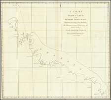
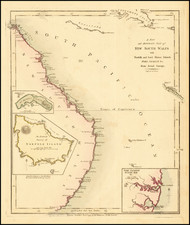
Carte de la Partie Septentrionale des Iles de Bougainville Reconnue Par le Contre-Amiral Bruny-Dentrecasteaux, en Juillet 1792. Levee et Dressee Par C.F. Beautempes-Beaupre
All of our maps are authentic antique maps, printed or drawn on or about the date shown in the description. In rare instances when we offer facsimiles, we will specifically describe the map as a later facsimile and include the date of publication. Certificates of Authenticity are included with each item.
Map Maker
Fast, Global Shipping
Last year we shipped over 4,500 antique maps to more than 50 countries. Maps are shipped Monday through Friday year-round. If an order is received before 2 PM PST, we will ship the order that day. If an order is received after that time, we will ship the next day. We ship maps either flat in custom packages or in specially ordered thick tubes. Shipping rates are provided as part of the checkout process.
Description
Fine early sea chart showin New Ireland and the Bougainville Islands.
This chart spans from the southern tip of Latangai Island (here called New Ireland) to the northwest coastline of Bougainville Island.
Bruni d'Entrecasteaux's route is traced and dated July 1792.