This item has been sold, but you can enter your email address to be notified if another example becomes available.


|
||

|

|
|

|
Stock# 64444
Description
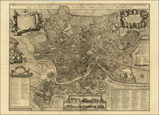
Handsomely-engraved antique folding map of Rome produced in Rome in 1862 by Luigi Piale.
The map was intended for Grand Tourists and has keys indicating Piazze, fountains, etc. Roman ruins are marked on the map, darker and set against the layout of contemporary Roman streets and buildings.
An inset map shows the "Contorni di Roma", the outlines or region surroundings of Rome.
Domenico Feltrini, Augusto Fornari, and Giovanni Montiroli were involved in the production of the print.
Condition Description
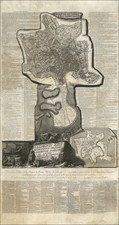
Dissected in 36 sections and mounted on original linen. Some minor separations of the linen. Linen cleanly separated along the central horizontal fold. Otherwise Very Good. Original marbled paper slipcase.
![[Rome / Controlling The Tiber River] Parer di Gio Paolo Maggio Archit Sopra l'inondation di Roma](https://storage.googleapis.com/raremaps/img/small/85891.jpg)
![[Spanish Siege of Ostia] Il Vero Disegno Del Sito Di Hostia e Di Porto Con Li Forti Fatti Dal Campo Di Sua Santita et Delli Imperiali Qualisi Resero Adi XXIIII Genaro M. D. L V II . . . .](https://storage.googleapis.com/raremaps/img/small/75401.jpg)