


|
||

|

|
|

|
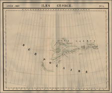
An Early Manuscript Map of the Great Lakes -- The Second Attempt To Map The Great Lakes
Exceptional, rare facsmilie map of one of the important early manuscript maps of the Great Lakes Ontario, Erie, and Huron (called "Lac Michigané").
The map shows Galinée's route from Montreal along the St. Lawrence River to the southern coast of Lake Ontario, the northern coast of Lake Erie, the eastern coast of Lake Huron, through Lake Nipissing and the French and Ottawa Rivers back to Montreal. Identifies portages, Indian villages and place names, and natural resources.
The map is drawn from the original manuscript map (now lost), possibly from the Service Hydgrographique archives in Paris. The map accompanied a facsimile of the manuscript report submitted by Galinée and fellow missionary François Dollier de Casson to New France intendant Jean Talon. Galinée's report, now in the Bibliothèque Nationale (Paris)
The title of the original map is Carte du Canada et des Terres decouvertes vers la lac Derie [and] Carte du Lac Ontario et des habitations qui l'Environment ensemble le pays que Messrs. Dolier et Galinee, missionnaires du seminaire de St. Sulpice, ont parcouru . . . (1670). As noted by Francis Parkman:
[The map] professes to represent only the country actually visited by the two missionaries. Beginning in Montreal, it gives the course of the Upper St. Laurence and the shores of Lake Ontario, the river Niagara, the north side of Lake Erie, the Strait of Detroit, and the eastern and northern shores of Lake Huron. Galinee did not know the existence of the peninsula of Lake Michigan, and merges Lake Huron and Michigan into one, under the name of "Michigane, ou Mer Douce des Hurons." He was entirely ignorant of the south shore of Lake Erie. He represents the outlet of Lake Superior as far as the Saut. Ste. Marie, and lays down the river Ottawa in great detail, having descended it upon his return. The Falls of the Genesee are indicated, as also the Falls of the Niagara, with the incription, "Sault qui tombe au rapport des sauvages de pus de 200 pieds dehut." Had the Jesuits been disposed to aid him, they could have given him much additional information, and corrected his most serious errors, as, for example, the omission of the peninsula of Michigan. The first attempt to map out the Great Lakes was that of Champlain, in 1632. This of Galinee may be called the second.
René de Bréhant de Galinée
René Bréhant de Galinée was a member of the Society of Saint-Sulpice (Sulpician Order) at Montreal and an explorer and missionary to the Native Americans. In 1670, he and François Dollier de Casson were the first Europeans to make a recorded transit of the Detroit River.
His map of the trip demonstrated that the Great Lakes were all connected.
Rarity
This small facsimile is quite rare. We find no auction records in the past 50 years.


![Factors of Prosperity in the Rock Island-Frisco States of America [cover title]](https://storage.googleapis.com/raremaps/img/small/94604.jpg)