This item has been sold, but you can enter your email address to be notified if another example becomes available.


|
||

|

|
|

|
Stock# 64441
Description
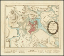
Wonderful example of Massachusetts and Rhode Island from Tanner's New Universal Atlas.
This map is hand colored by county and contains great detail, including, waterways, travel routes, and rail lines. A statistical inset provides population by county. Large inset map shows a detailed plan of Boston with references to the major points of interest.
Tanner's New Universal Atlas became the standard work in the Industry until Tanner sold the rights to the atlas in 1846 to SA Mitchell.