This item has been sold, but you can enter your email address to be notified if another example becomes available.


|
||

|

|
|

|
Stock# 64384
Description
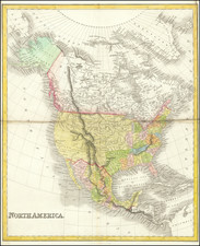
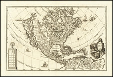
Detailed map of North America, showing Coahuila and Texas, Upper California and a 54-40 or fight Oregon Territorial border with British America (Canada).
One of the earliest atlas maps to show Texas Independence.
Fine detail in the Transmississippi West, especially the river systems of the Mississippi and Missouri.