|
||

|

|
|

|
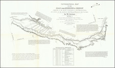
St. Louis to Astoria, Oregon in the 1810s—the Hunt and Stuart Expeditions
Intriguing early map of the routes of Hunt and Stuart, two of the earliest American overland travelers, immediately following Lewis and Clark.
The map illustrates Wilson Price Hunt's westward expedition from the Missouri River to John Jacob Astor's trading post on the Columbia River, and Robert Stuart's trip from Astoria to St. Louis. Wheat remarks that, "the map is reasonably accurate, and is an important milestone in western mapping."
Hunt and Stuart were perhaps best known for having discovered what would become known as the Oregon Trail, this being one of the earliest appearances of the routes of Hunt and Stuart on a printed map.
The map is cleanly drawn and open, highlighting the riverine networks and mountain ranges of the American West. Major rivers are labeled, including the Mississippi, Kansas, Platte, Colorado, Missouri, and the Columbia. Hunt and Stuart’s routes are shown with dotted and dashed lines, respectively.
The expedition of Wilson Price Hunt
The Hudson’s Bay Company (HBC) began in 1670 to trade furs in the North American Northeast. While they controlled a massive area—the drainage basin of Hudson’s Bay, called Rupert’s Land—they wished to the be the sole fur traders in the North. They faced stiff competition, however.
The magnate John Jacob Astor hoped to make his Pacific Fur Company a profitable competitor. To gain an edge in geographic knowledge, Astor financed an expedition overland and chose Wilson Price Hunt to command it, as well as to be his St. Louis agent.
Hunt left St. Louis with a party of sixty men in October 1810. They first canoed 450 miles on the Missouri River, then headed overland on foot and horseback. Hunt had few outdoors experience, but he did prove skilled at negotiating encounters with indigenous groups. By summer of 1811, Hunt had reached the Snake River, where valuable supplies were lost while attempting to canoe the rapids.
Hunt split his group into two, with each attempting to reach the Columbia on their own. Both parties eventually arrived in Astoria, at the mouth of the Columbia, by early 1812. Once there, Hunt continued by ship to Russian Alaska and Hawai’i. He returned to Astoria in August 1813, only to find that the partners wished to abandon the settlement. The post was to be sold to the Northwest Company, another rival of the HBC.
After the Pemmican War of 1816, the two companies were forcibly merged by the British government. This merger resulted in a major reorganization and created the Columbia Department of the HBC to cover the Pacific Northwest. The regional headquarters were at Fort George (Fort Astoria), which was then moved to Fort Vancouver on the Columbia.
The expedition of Robert Stuart
Stuart was also a partner of the Pacific Fur Company. He sailed on the Tonquin, the Company’s ship, around Cape Horn to the Pacific Northwest. They established Fort Astoria in May 1811. The Tonquin continued to trade up the coast, but its crew was killed, and the boat destroyed, in an altercation with the Tla-o-qui-aht nation. Stuart was part of the overland expedition that was to deliver news of this setback.
Stuart and his party traveled up the Columbia, then along the Snake River to American Falls and Soda Springs. This would become a crucial part of the Oregon Trail. They explored Wyoming, then followed the North Platte River, arriving in St. Louis in late April 1813.
Stuart’s path became essential to later travelers. It and his adventures were popularized in Washington Irving’s Astoria.
Lake Bonneville and Benjamin Bonneville
The Great Salt Lake is labeled here as Lake Bonneville, which was named for Benjamin Bonneville, an Army officer and explorer. The godson of Thomas Paine, the pamphleteer, Bonneville entered the United States Academy at West Point in 1813. He served part of his early career in Arkansas Territory, his first experience with western posts. In 1824, he was promoted to Captain at Fort Gibson, in Indian Territory, and later served in Missouri.
While in Missouri, Bonneville became caught up in the excitement over the Oregon Territory. He became friends with Oregon promoter Hall J. Kelley and was appointed by Kelley to lead an expedition to Oregon in 1832. However, this expedition was cancelled due to a lack of volunteers.
Taking a leave of absence from the army, Bonneville planned his own western expedition. He was supposed to gather reconnaissance about indigenous presence in the area, as well as any other information that might be useful to the United States, who hoped to counter British interest in Oregon and claim it as a future state. The trip was paid for by donors, including John Jacob Astor.
Bonneville set out with 110 men in May 1832. They ranged from Missouri to Wyoming and into Idaho, along the Snake River. He sent a smaller party to explore the Great Salt Lake and, hopefully, find a route to California. Led by Joe Walker, the group blazed what would become the California Trail, which would be heavily used during the California Gold Rush.
In early 1834, Bonneville continued into the Wallowa Mountains, where he interacted with the Nez Perce people. When the Hudson’s Bay Company commander at Fort Nez Perces refused to trade with him, Bonneville returned to Idaho. He tried to move west again later in the year but was further rejected in attempts to trade. By spring 1835, Bonneville started back to Missouri. Like Stuart and Hunt, much of his wanderings would become the basis for the Oregon Trail.
These adventures were later taken up by Washington Irving, with whom Bonneville partnered to write the account of his expedition. The Adventures of Captain Bonneville was published in 1837, just after this map was published.
Today, Lake Bonneville is the name of the ancient, massive lake that covered much of Utah, Nevada, and Idaho. This name was given by the geologist G. K. Gilbert in the late-nineteenth century, after the Great Salt Lake had gained primacy as the name for the remaining lake. Today, Bonneville’s name also lives on with the Bonneville Salt Flats, which are famous for racing.
Carey, Lea & Blanchard refers to one of the iterations of the Carey publishing firm, which was the largest American publishing house of the nineteenth century. Mathew Carey founded the firm in the 1790s and brought in his son, Henry Charles Carey, in 1817. In 1822, Mathew’s son-in-law, Isaac Lea, joined as well, while Mathew retired. William A. Blanchard joined the firm in 1833, causing another name change to Carey, Lea & Blanchard. Henry retired in 1835, leaving the firm as Lea & Blanchard.
![[The Indian Tribes of California] Karte Übersicht zur Verbreitung der Indianer-stämme in Kalifornien](https://storage.googleapis.com/raremaps/img/small/96549.jpg)
![[Kansas City - Witchita - Tulsa - Enid - Springfield] Kansas River (360) World Aeronautical Chart](https://storage.googleapis.com/raremaps/img/small/96224.jpg)