


|
||

|

|
|

|
Including The First Public Garden In Europe!
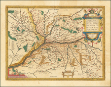
Finely executed manuscript plan of Nimes in the south part of France, almost certainly drawn in connection with the work of Jacques Philippe Mareschal between 1740 and 1749.
Drawn in the classical style of French Military Engineers of the period, the map is centered on the urban core of Nimes, including the old city walls and the Roman Arena at the bottom of the city center (#10). Beyond the walls, the more modern neighborhoods of Nimes are shown, along with the Citadelle (top center) and the Jardines de la Fontaine (Fountain Gardens), a Roman ruin which was just then being restored and rebuilt to its modern grandeur (see below).
At the far right, an unnamed Canal is almost certainly the proposed canal to the sea proposed, but never built, by Jacques Philippe Maeschal, the Royal Engineer of Louis XV who oversaw the excavation of the Roman Ruins in the Fountain Gardens and construction at the site which currently exists. As noted in Tradition and Innovation in French Garden Art:
Arguably the most spectacular instance of designing public green space as part of a master plan for urban expansion occured in Nimes. The success of the local textile industry in the 18th Century generated wealth and steady increase in population. Housing, however, was in short supply, and increased demand by residents and industry strained the city's primary source of water, the ancient sprints at the base of Mont-Cavalier outside of the city walls to the west.
Following a drought in 1719, governmental officials began exploring ways of improving the collection and distribution of water. This engineering problem rapidly expanded in scope and designers assigned to the task realized that they had an opportunity to integrate the planning of the water supply with the expansion of the city beyond its walls. The presence of ancient Roman ruins around the springs offered incentive to think of beautification as well as utility.
In 1744 the crown assigned responsibilty for the expanded scope of work to the provincial director of fortifications, Jacques Philippe Mareschal. He addressed the water supply problem by enlarging the collection basin at the spring and building a new canal to conduct water to the heart of the city. Along the canal, he planned a promenade that intersected with a tree-lined boulevard, the present Avenue Jean Jaures, which formed the spine of the new district that more than doubled the areas of the city. . . .
The focal point of the entire development was the ancient spring, which Mareschal transformed into the Jardin de la Fontaine. He valued the Roman remains and integrated them into his design by retaining portions of their plan and incorporating ancient stone into new construction. His work was not an archaeological restorations but an effort to provide Nimes with a living link to its ancient origins. . . .
Mareschal divided the garden into five zones. The first consisted of approaches from the old city to the east and the new district to the south, which were lined with trees and small pavilions. Gates separated the approaches from the next three zones forming the garden proper. The garden zones include an island formed by the major Roman remains, and terraces ascending the south of Mont-Cavalier. The fifth and final zone was a terrace to the west that contained an obelisk dedicated to the city's prosperity under the beneficial rule of Louis XV>
Jardins de la Fontaine
The Jardins de la Fontaine (Fountain Gardens) is a classical garden begun as a pubilc beautification project in the 18th Century, further constructed in in the 1800s and a landscaped Mediterranean garden created in the 1900s.
The work carried out at that time to dig the vast pond and construct the monumental stairway uncovered much older vestiges of a place of worship set up near a spring, hence its name. Already ub existence at the time of the Celts, a religion was centered around Nemausus and a dedication to Nîmes goddesses has been found.
But it was the Romans who built a temple devoted to Augustus, with a whole architectural ensemble centered around the nymphaeum and including the very romantic vaulted edifice of the Temple of Diana, the function of which remains a mystery. It may
Today, the gardens are richly ornamented with baroque sculptures and huge urns. New spaces have been created, such as the rock garden, the Montgolfier pond and the Mazet.
The district of the Jardins de la Fontaine first developed during the Gallo-Roman period and is one of the oldest parts of Nimes. Recent excavations have, in particular, unearthed traces of a working-class indigenous neighborhood, a rich Second century mansion ( Rue Pasteur) and, at the intersection of Jaurès Boulevard and Rue de Sauve, a sumptuous public building whose use remains mysterious.
In the 18th century, beginning in 1739, work to regulate the flow of the spring uncovered many vestiges of the Roman period, including a shrine dedicated to Augustus and an ancient theater (unfortunately buried and not included in the general development project).
The Fountain Gardens were built between 1745 and 1755 on the basis of these remains. The Fountain Gardens highlight two other Roman monuments that survived, the Temple of Diana and the Magne Tower. The project was led by Jacques Philippe Mareschal, military engineer of King Louis XV and director of the fortifications of the province of Languedoc.
The Fountain Gardens were classified as historical monuments by the 1840 decree and the whole site is now an historical monument and on the list of remarkable gardens in France, gardens benefiting from a label awarded by the Ministry of Culture. The entrance to the gardens, marked by three large wrought iron gilded gates constructed in the 1750s, which arms of the city.
Mareschal would ultimately rise to the title of Royal Enginner. He began his career in Belfort as head of the provinces of Alsace and Burgundy.
In 1715, he created a manuscript atlas of the places of Alsace which brought together the different plans found throughout the province. This atlas is kept at the Château de Vincennes, at the Génie library in Paris .
In 1721 , Jacques Philippe was appointed Knight of Saint-Louis and made chief engineer in Huningue . He was then appointed director of the fortifications of the duchy and county of Burgundy, for a few months, from 1738 .
In 1737, he erected the Saint Louis tower in Port-Saint-Louis-du-Rhône.
He worked at the Jardins de la Fontaine in Nîmes ( Gard ) from 1740 to 1749. He created plans during the ancient discoveries and also plans for a sea canal project in Nîmes, but the latter was not carried out.
In 1748, he traveled to Italy at the request of Benedict XIV , to provide advice and plans for the port of Anzio.
Mareschal drew nother atlas for the places of Languedoc in 1775 . This manuscript contains plans for military constructions such as the redoubt of Grau-du-Roi , the towers of Aigues-Mortes, the forts Saint-Pierre and Richelieu de Sète, nd maps of cities and their surroundings such as Narbonne and Agde.
Mareschal built the first concert hall in Montpelier in the 18th century.
![[ France ] Galliae seu Franciae Tabula, qua omnes Provinciae, Viae angiariae, et aliae res notatu dignae distincte et accurate ostenduntur . . .](https://storage.googleapis.com/raremaps/img/small/98436.jpg)

![(Second World War - D-Day - Omaha Beach) OMAHA BEACH-EAST (Colleville-sur-Mer) [:] FIRST BEACH OBSTACLE OVERPRINT [with:] OMAHA BEACH-WEST (Vierville-sur-Mer) [:] FIRST BEACH OBSTACLE OVERPRINT. NP, April 21, 1944 (with overprinting of information dated May 12).](https://storage.googleapis.com/raremaps/img/small/100123.jpg)