|
||

|

|
|

|
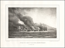
Extermination of the Lipan Indians in Northern Mexico
Finely executed map of part of Coahuila and Chihuahua, illustrating the theater of war between the Mexican Cavalry and the Lipan Indians.
At the direction of President Porfirio Diaz in 1881, the Mexican' Army's Diaz Division conducted raids intended to wipe out the "savage tribes" along the Texas-Mexico border. Utilizing maps prepared by Major Blas Flores showing the location of all the Indian camps and rancherias, the soldiers were ordered to burn the villages and kill all inhabitants, regardless of age or sex. The intent was to retaliate against acts committed by Apache and other bands in the Rio Grande region. Diaz also believed all Indian peoples were hiding resistance fighters from the regional governors and hacienda owners.
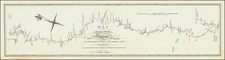
Major Blas María Flores participated in two three-pronged military expeditions against the Apaches that he describes in a document he presented to the Mexican government as part of an overall plan for colonizing the northern desert. He prepared a detailed map of the area showing population centers, routes, and favored haunts of the Indians to support his argument for the strategic placement of military colonies to protect settlement and investment. His discussions of the various Indian groups compare linguistics, appearance, clothing, customs, and kinship.
The map locates cities, towns, regulated military colonies, American forts, estates and ranches, permanent watering, temporary watering, places without water, ranches or dens of Indians and fords. The border is also indicated and with colored lines the advance of the military columns of the expedition against the "savage tribes". The map covers the area between the Rio Bravo del Norte and Monclova, to the south.
This is an excellent map, a sample of the cartographic quality of the late 19th century. The map shows Major Flores' military strategy for the extermination of the last indigenous rebel redoubts of the border.
The map appeared in work entitled Exploración practicada en el desierto de Coahuila y Chihuahua por el Mayor de Caballería: Blas M. Flores, México: Oficina Tipográfica de la Secretaría de Fomento, 1892
The title of the map translates as:
Sketch of the Coahuila Desert and Part of the Chihuahua where the expedition against the savage tribes took place in the months of June and July 1881 by order of the Secretary of War. Under the direction of the Cavalry Major Blas M. Flores. Commander of the 9th Rural Corps.
Rarity
The map and pamphlet are extremely rare. We find no auction or dealer records for the map or pamphlet.
![(California-Mexico Border Survey) Datos de los trabajos astronómicos y topográficos. [bound with:] Variedades de la civilizacion, nueva epoca (Tomo I)](https://storage.googleapis.com/raremaps/img/small/70777.jpg)