|
||

|

|
|

|
Fascinating Early Antarctic Treatment
Extremely rare pair of maps of the northern and southern hemisphere, pubished in Berlin in 1754.
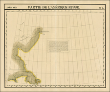
Northern Hemisphere
The map of the northern hemisphere provides a good early image of the Russian Discoveries in the area around Alaska, and includes the major mythgs of the time, including:
- Fusang of the Chinese -- Early Chinese Discovery of America
- Bay of the West, with a river reaching Hudson Bay
- Curious River attributed to De Fonte, extending to Baffin Bay.
- Wide open Northwest Passage
Perhaps most fascinating is the tracks of the arctic voyage of David Melgueiro in 1660. Melgueiro was supposed to have been a Portuguese navigator and explorer. He allegedly sailed across the Northeast Passage in 1660 by travelling from Japan to Portugal through the Arctic Ocean, at a time when Portuguese vessels were banned from Japan. According to the story of a diplomat and French spy in Portugal, the Seigneur de La Madelène (or Madeleine), he found records that a Captain David Melgueiro, at the command of the Dutch ship Eternal Father, left the island of Tanegashima, Japan (Kagoshima Prefecture) on March 14, 1660, sailed north and entered the Arctic Ocean through the Bering Strait (known at the time as Strait of Anian). The expedition reached 84° N and, upon sighting Svalbard, headed south, towards Scotland and Ireland. Carrying on board a number of emigrant passengers back to Europe with valuable goods. The ship finally arrived in 1662 at Porto, Melgueiro’s birthplace.
La Madelène was allegedly murdered when he was preparing to leave Portugal to reveal Melgueiro’s achievement to the French. In 1754 the French geographer Philippe Buache traced in his memoirs the route taken by Melgueiro on a 1649 map drawn by a Portuguese identified only as Teixeira. The map was found in the French Navy archives. How the French Navy acquired this map would be a Portuguese state secret as well. Modern scholars dismiss the veracity of the story.
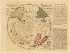
Southern Hemisphere
The southern hemisphere shows a remarkably eleaborate Antarctic continent, referencing the discoveries of a number of dubious reports regarding the discovery of a landmass in the South Polar regions. These include:
- Sir Francis Drake's first viewing of an island in 1680 (should be 1580).
- Gallego (1567). the expedition in search of Terra Australis led by Álvaro de Mendaña y Neira, a Spanish navigator who led two voyages of discovery he led into the Pacific in 1567 and 1595 in search of Terra Australis. Hernando Gallego was one of the navigators.
- Lands discovered in 1714 by the Brig Espagnol
- Jacob Roggeveen's voyage of 1721 on behalf of the Dutch East India Company.
- The lands seen by Pedro Fernandes de Queirós in 1605.
- Abel Tasman's discoveries in 1643
- The discoveries of the 1738-9 voyage of Jean-Baptiste Charles Bouvet de Lozier
![[Grotto of Tethys -- Versailles] Le Soleil qui se couche dans la mer / Le Globe de la Terre, divise en six parties.](https://storage.googleapis.com/raremaps/img/small/79606.jpg)
![(Strait of Magellan) Freti Magellanici ac novi Freti vulgo Le Maire exactissima delineatio. [The most exact delineation of the Strait of Magellan and the new Strait, commonly known as Le Maire.]](https://storage.googleapis.com/raremaps/img/small/99612.jpg)