|
||

|

|
|

|
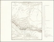
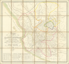
The First Wall Map of The Mexican Republic Published in Mexico
Fine example of the first official map of Mexico published in Mexico from indigenous surveys.
Antonio Garcia y Cubas' map of Mexico is the first official map of Mexico, printed in Mexico and prepared from Mexican sources. The map reflects the culmination of Mexico's 30-year effort to produce an indigenous map, which began with the efforts of the Instituto Mexicana de Geografia y Estadistica (later Sociedad Mexicana Geografia y Estadistico or SMGE, established in 1833) to create a map of the newly independent Mexican Republic.
The Garcia Cubas map has one of the most remarkable cartographic stories of any national map. It begins with the lost manuscript maps of Pedro Garcia Conde of 1845 and his surreptitiously printed map of Mexico and ends with this spectacularly detailed production by Garcia Cubas, showing the tremendous progress in Mexico's indigenous printing in the middle of the 19th Century and demonstrating the fine skills of Mexico's indigenous lithographers.
Producing Mexico's First National Map
One of SMGE's first major projects was to create a Carta General of the new Republic. SMGE commissioned Pedro Garcia Conde to lead the project. The son of Diego Garcia Conde (maker of the first indigenous wall map of Mexico City) and then one of Mexico's most important military leaders and surveyors, Pedro Garcia Conde would later go on to head the Mexican Boundary Commission Survey for Mexico in 1848. Garcia Conde prepared and distributed a questionnaire throughout the Republic, seeking information on the towns, villages, mines, mountains, rivers and other cartographic features of the country. With the responses, he prepared a large-scale manuscript map. Unfortunately, fate and the underfunded status of the Mexican Government intervened, and no official publication of the manuscript map occurred, although Garcia Conde was able to secretly print a 4-sheet version of the map, with the help of Benjamin Rees Davies, one of London's leading independent map engravers.
According to UNAM Profession Hector Mendoza Vargas, when word got back to Mexico City that Garcia Conde was attempting to have a copy of the map engraved privately, he received a stern written warning from SMGE not to have the map published. However, it is now clear that Garcia Conde concealed his completion of the printed version of the Carta General from SMGE and the Mexican Government, as no copy of the map is known in Mexico and none of the contemporary or modern scholars on the history of the mapping of Mexico mention the map.
The Quest For Mexico's First Official Map Continues
The lack of knowledge of the existence of Garcia Conde's map is clear in the writings of some of his contemporaries. Antonio Garcia y Cubas, Mexico's most famous 19th Century mapmaker, states in his summation of the Armistice of 1847, "our history is written simply by saying the Mexico and the United States are neighbors. At least France and England are separated by a Channel; between our nation and our neighbor there exists no other border than a simple mathematical line . . . God help the Republic!" (Collado, Antonio Garcia y Cubas, p.443). Similarly, the members of the Comision de Estadistica Militar in 1848 stated "How can one expect to understand the nation's territorial extension, or consult regarding its defense, without the formation of a general map and one of each State and territory." (see Mendoza Vargas, 55). Translations are from Craib, Cartographic Mexico.
In Cartographic Mexico, Craib notes,
Under these less than auspicious circumstances the SMGE's new national map, hastily finished in the aftermath of the War and during the initial phases of the boundary demarcation, appeared in 1850. . . It included a visual elaboration of the territory lost in the Treaty of Guadalupe-Hidalgo, as well as a demarcation of the new international limits between Mexico and the United States. . . . [According to Garcia Cubas in his El Libro de mis recuerdos (p.452)], the image brought an expression of bitterness from General Santa Anna, who for the first time could actually envision the magnitude of the territory Mexico had lost. The map never saw publication because of the government's precarious financial condition after the war. Members of the Comision and [SMGE] sought publishers in the United States and England, but found the prices for publication no more accommodating than Mexico. . .
The need for a published and circulated, Mexican-produced, national map became even more pronounced when in 1854, Mexico lost another portion of its territorial claim as a result of errors in the [Disturnell] map . . . Regardless of the role General Antonio Lopez de Santa Anna and others played in the politics of the [Gadsden] Purchase, Mexican officials and intellectuals were convinced: Mexico needed an accurate and internationally accepted map of its own, published and circulated.
After the war, a new Carta General, constructed by Garcia Cubas, would proffer an iconographic image of the state's new parameters and fill that territory with the ghosts of the past, in the process creating an image of a single national spirit.
Craib (p. 25-27).
In fact, it was not until 1863 that Garcia y Cubas' finally printed a large format map of Mexico, which would become Mexico's first official map. Prior to this time, Garcia y Cubas had published his Atlas Geografico, Estadistico e Historico de la Republica Mexicana, formado por Antonio Garcia y Cubas, the first atlas of Mexico.
The map is dedicated to Don José Fernando Ramirez, the distinguished Mexican historian, who chaired the Mexican Ministry of Foreign Affairs under three different administrations and served on Mexico's Supreme Court, as well as leading Mexico's Academy of Sciences and Literature.
While Garcia Cuba's map would later be critiqued as a compilation, rather than published based upon astronomical observations and surveys, it is without question the most beautifully executed and symbolically important map of Mexico published in the 19th Century and a foundational work for collectors.
Rarity
The map is very rare on the market. This is the third time we have offered the map for sale in the past 20+ years.
Antonio García y Cubas (1832-1912) was a Mexican geographer, historian, writer, and cartographer. An orphan from a young age, Cubas attended the Colegio de San Gregorio and the Colegio de Ingenieros, where he earned a geography degree. In 1856, he became a member of the Sociedad Mexicana de Geografía y Estadística.
Cubas wrote several geographic works, including introductory courses to geography, historical atlases, and maps. He is best known for his Atlas Geográfico, Estadístico e Histórico de la República Mexicana (1857), Carta General de México (1863), and Diccionario Geográfico, Histórico y Biográfico de los Estados Unidos Mexicanos en cinco volúmenes, editados entre 1888 y 1891. He is also praised for his memoir, El Libro de mis Recuerdos (1905). Today, the best books published in anthropology and history in Mexico are given the Antonio García Cubas prize.


![(Mexican-Aztec Painting) [Watercolor of Aztec Deities from the Codex Telleriano-Remensis and Codex Vaticanus]](https://storage.googleapis.com/raremaps/img/small/103008.jpg)