|
||

|

|
|

|
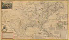
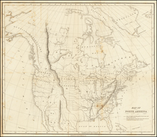
The 1640 Complete Champlain Voyages, with Unbroken Provenance to an 18th-Century Earl. Accompanied by Champlain's Largest and Most Accurate Map. "The first [map] to depict the existence of the entire Great Lakes network" - Burden (237).
A superb Americanum, the 1640 Les Voyages de la Nouvelle France... is the final, most-complete edition of Champlain's Voyages. The book describes the events in Nouvelle France up to 1629. It is accompanied by a large two-sheet map that deserves a host of accolades: it is the largest and most detailed of Champlain's maps; it is the first map to depict the entire Great Lakes network; it is the first delineation of present-day New York City on a printed map.
Church described the importance of the book as an overview of French exploration in the New World up to 1629:
"It is perhaps the most important of the old editions, as it contains a collective narrative embodying a review of all preceding French expeditions to the New World, followed by and interwoven with Champlain's own voyages to Canada: a short account of the First (1603), which had been published in 1604; and an abridgment of the Second, Third, Fourth, Fifth and Sixth (1608-1613), as they had been published in the volume dated 1613. These voyages end on p. 210. Pages 239-308 contain the Seventh Voyage (1615-1616), while the Eighth Voyage (1617) is only mentioned between pp. 211 and 214 as unimportant. The Second Part contains the Ninth Voyage and a History of Canada (1620-1631), pp. 1-310; a Treatise on Navigation, pp. 1-54; followed by the doctrine Chrestienne du R.P. Ledesme and l'Oraison Dominicale par le R.P. Massé, with separate signature-marks and pagination. This was the last of Champlain's works."
The collected Champlain was first published in 1632, in three different imprints, those of Claude Collet, Pierre Le Mur, and Louis Sevestre. This 1640 edition was issued by Collet.
The Map: Carte de la nouvelle france, augmentée depuis la derniere
This is Burden's second state of three states, with the circular unstippled area in the Grand Banks off Newfoundland.
This is one of the three great maps by Samuel de Champlain, the others being his Carte géographique de la Nouvelle Franse faicte / par le Sieur de Champlain Saint Tongeois Cappitaine ordinaire pour le Roy en la Marine, faict len 1612 (Burden 160) and his Carte geographique de la Nouvelle franse en son vray moridia, also from 1612 (Burden 161).
The present map is the largest of Champlain's maps; it is almost 40% larger than his Carte... Nouvelle Franse faicte... from 1612. The new map extends the scope of Champlain's earlier cartography to the south, below Chesapeake Bay; west, to Lake Superior (Grand lac.); and north, further into the Canadian arctic west of Hudson's Bay (MER DU NORT GLACIALLE.) The map is large enough that it needed to be printed from two copper plates on two sheets of laid paper (here joined as one, as usual).
The symbol of a church placed at the site of Manhattan Island, Burden notes, “must be construed as the first delineation of present day New York City on a printed map.”
Commentary on the Complete Champlain
"…extremely rare and sought after" (Leclerc, Bibliotheca Americana, 695)
"The most complete and very rare edition of Champlain" (Chadenat, 2578)
"Of all the editions of the book of Champlain, this is the most complete" (Leclerc)
"This edition is the only complete one of Champlain's voyages [...]. The great map is printed here for the first time. An imperfect facsimile of the large map is usually substituted for the rare original [...]. This work gives us the first accurate accounts we have of the Indians of the interior of the present state of New York. It is very largely devoted to descriptions of their habits, modes of life and warfare; and of personal observations and experiences among the Algonquins and Iroquois. The most remarkable event in Indian history was caused by Champlain's first visit to the shores of the lake bearing his name. in a conflict between the two named races of savages, he gave the victory to his friends the Abnaquis, by the use of his musket. The Iroquois never forgave the injury, and thousands of Frenchmen were slaughtered to avenge it" (Field)
Champlain in New France from 1629 - 1635
Burden provides the following summary of the last period of Champlain's life:
The intervening years since Champlain's last publication were not occupied with personal exploration, that part of his life was over. His young wife Helene came over to Quebec in 1620 and abhorred the place from the start. She remained four years and returned in 1624 to Paris, never to go back. In 1625 the first of the Jesuit priests arrived that were to have a great influence on the knowledge of the interior in future years. In 1627 hostilities began between England and France, and Acadia was taken by the English soon after. The English under David Kirke arrived in the St. Lawrence River the following year and laid siege. Champlain managed to bluff his way to the winter. In 1629 however they returned and had little choice but to surrender and accept transport back to Europe. He immediately started working tirelessly for the return of the territories to France. The Treaty of Saint Germain en Laye signed in March 1632 achieved this for the small price of payment of an old debt. King Louis XIII owed the English crown 600,000 ecus as a dowry for his sister Henrietta Maria when she married Charles I. Champlain returned to Quebec in 1633 and was never to see France again. He suffered a stroke in October 1635, and died on Christmas Day. At that time Quebec could claim just 200 people, whereas the English colonies numbered already many thousands. The French were just not interested in the New World as a place to colonise. The English, however, were full of it; books, poems, and plays talked of little else and were very positive about life there.
Provenance:
Thomas Hamilton (1721-1794), 7th Earl of Haddington (with his engraved armorial bookplate);
Thence by descent in the Library of the Earls of Haddington;
From whom we purchased the book in November 2019 in partnership with HS Rare Books