|
||

|

|
|

|
A Rare Pair of Ottens Maps of the Northern and Southern Hemisphere, made especially to commemorate Lozier Bouvet's 1738-9 voyage.
Fine pair of maps of the northern and southern hemispheres, originally by Guillaume Delisle and here re-issued by Ottens.
Each hemisphere is presented on its own sheet, with the round map filling the center. At the top, the title runs on either side of the circle, with additional text in French and Dutch below. Each includes significant additional text described below.
Overall, there are two points of interest that a reader would notice right away. First, the hemispheric, circumpolar projection has the opposite effect of the more-common Mercator projection. The Mercator projection inflates land masses at the northern and southern poles while showing regions closer to the Equator in their correct proportion. This projection, conversely, shows the Polar regions correctly and distorts Equatorial areas.
The other detail of note is the presence of the vast empty spaces at both poles, as well in northwestern North America, portions of Australia, and New Zealand. These blank spaces were a major innovation by the original mapmaker, Guillaume Delisle. Unlike many of his contemporaries, Delisle preferred blank spaces to conjecture or decorative embellishment. If he did not know the shape of a coast, he left it out or at least marked it with a dotted line. This approach is emblematic of the more scientific approach to mapmaking adopted in the eighteenth century.
Northern Hemisphere:
Looking at the northern hemisphere, California is shown as a peninsula, correcting one of the great cartographic blunders of the period, the creation of California as an island. At this time, many mapmakers showed the peninsula as insular. Although Father Eusebio Kino had published his refutation of this trend in Paris in 1705, mapmakers were slow to revert back to the actual peninsular form.
Across the Pacific, Japan, or Niphon as it is written here, is shown horizontally, a typical depiction for the time. To the northeast is an unfinished island called Terre de la Compagnie. A nearby note explains that the coast was discovered by Jean de Gama. This explanation actually elides two popular cartographic chimeras of the time. Juan de Gama, the grandson of Vasco de Gama, was a Portuguese navigator who was accused of illegal trading with the Spanish in the East Indies. Gama fled and sailed from Macau to Japan in the later sixteenth century. He then struck out east, across the Pacific, and supposedly saw lands in the North Pacific. These lands were initially shown as small islands on Portuguese charts, but they ballooned into a continent-sized landmass in later representations.
Several voyagers sought out de Gama’s lands, including the Dutchmen Matthijs Hendrickszoon Quast in 1639 and Maarten Gerritszoon Vries in 1643. Vries commanded the Castricum, while Hendrick Cornelisz Schaep was in charge of the Breskens. Compagnies Land, along with Staten Land, were islands sighted by Vries on his 1643 voyage. He named the island for the Dutch States General (Staten Land) and for the Dutch East India Company (VOC) (Compagnies, or Company’s Land). In reality, he had re-discovered two of the Kuril Islands. However, other mapmakers latched onto Compagnies Land in particular, enlarging and sometimes merging it with Gama’s island.
The text surrounding the hemisphere reveals one of the sources for this updated work, a map by Jean Kyrilow, Secretary of the Council of the Empire of Russia published in 1734. His map was used to provide a more complete outline of Kamchatka and northeast Russia than Delisle had included on his 1714 edition. A letter from a Dutch resident of St. Petersburg, a Mr. Swartz, is included.
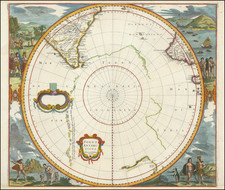
Southern Hemisphere
This fascinating map captures the entire Southern Hemisphere from a polar projection. This rare variant example includes an additional text panel describing Lozier Bouvet's voyage, added to the right side of the map. The cartography features many of the contemporary myths and anomalies associated with the Antipodes. The map features excellent projections of Australia and New Zealand, along with a number of early routes of exploration from the 16th, 17th and 18th Centuries, including Tasman, Halley, Damiper, Magellan, Le Maire, Mendana and others.
The "port", allegedly discovered by Sir Francis Drake, otherwise known as Drake's Island, in 1577, lies to the southwest of Cape Horn. Some of the more notable features are Edmund Halley's sighting of Antarctic ice; Bouvet's large Cap de la Circoncision; Carpentaria attached to New Guinea; Tasman's route, along with a depiction of Tasmania as per Tasman, distinctly separate from Australia.
Emphasized on the map (heightened in orange) is the route of the 1738-9 voyage of Jean-Baptiste Charles Bouvet de Lozier (1705-86), commanding the ships Aigle and Marie, undertaken at the behest of the French East India Company. Bouvet's mandate was to find the apocryphal great southern continent. The text mentions Bouvet's discovery of icebergs between two and three hundred feet high and half a league to two or three leagues in circumference. On January 1, 1739, Bouvet encountered an icy promontory, which he named Cap de la Circoncision, at 54° South, below Africa, supposedly located next to one of the openings of his polar sea, where he had recorded his many great icebergs. An inset in the lower right of the map details this discovery.
Importantly, this was the first time land had been spotted beyond the 50th parallel South in the Eastern Atlantic. Bouvet, spotted Cap Circoncision, but severe fog and ice ensured that he was unable to explore the area further, and thus he was unaware that the landmass was part of an island, and not a southern continent. Bouvet lost sight of the cape and was unable to relocate it in the days that followed. For many decades after this map was printed, it remained a mystery as to the true nature of this discovery. Bouvet's plotting of his course was inaccurate, and in spite of several attempts, the cape was not encountered again until 1808, when it was proven to be an island. Named Bouvet Island, it is one of the World's most isolated points of land, very distant from both Africa and Antarctica, and is today administered by Norway.
The Ottens brothers, Reiner and Joshua, operated a successful printing partnership in the mid-eighteenth century (fl. 1726-1765). They began the venture in 1726, publishing maps and other prints as “R & I Ottens.” They specialized in the reprinting of others’ work, especially Guillaume De L’Isle. In 1750, Reiner died; his soon, also Reiner, took his place, but the firm began listing their works as “Joshua & Reiner Ottens.” The firm lasted until Joshua’s death in 1765. Joshua’s widow, Johanna de Lindt, sold their remaining stock of plates in 1784.
![[ Discovery of the Northwest Passage ] Chart Showing the Recent Search for a North-West Passage. Also the Coast Explored in Search of Sir John Franklin between the Years 1848 and 1854](https://storage.googleapis.com/raremaps/img/small/101874.jpg)