


|
||

|

|
|

|
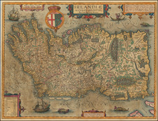
Fine example of the Ortelius/Vrients edition of Baptista Boazio's remarkable map of Ireland, engraved by Elstrach and published by Sudbury in 1599.
Decorative map of Ireland with north oriented to the right. The Island is divided into the four provinces of Ulster, Connaught, Leinster and Munster with counties delineated by dotted line. It is filled with pictorial depictions of the forests and topography and the location of cities, towns and major landowners. A table to the left deciphers the Irish names relating to geographical features and residents, noting that the presence of O before a name indicates Caput familiae, or the head of the family, and Mc before a name indicates a Territorium fillii Satrapae, a region dominated by one related family. The sea is teeming with sea monsters and a pair of elegantly engraved ships, one of them aflame. A man in a curragh waving a trident is shown in the upper right near the dedication cartouche, and three other elaborate strapwork cartouches further adorn the map.
Boazio's of Ireland is one of the maps added by Joannes Baptista Vrients when he took over publication of Ortelius ' Theatrum Orbis Terrarum after Ortelius' death.
Abraham Ortelius is perhaps the best known and most frequently collected of all sixteenth-century mapmakers. Ortelius started his career as a map colorist. In 1547 he entered the Antwerp guild of St Luke as afsetter van Karten. His early career was as a business man, and most of his journeys before 1560, were for commercial purposes. In 1560, while traveling with Gerard Mercator to Trier, Lorraine, and Poitiers, he seems to have been attracted, largely by Mercator’s influence, towards a career as a scientific geographer. From that point forward, he devoted himself to the compilation of his Theatrum Orbis Terrarum (Theatre of the World), which would become the first modern atlas.
In 1564 he completed his “mappemonde", an eight-sheet map of the world. The only extant copy of this great map is in the library of the University of Basel. Ortelius also published a map of Egypt in 1565, a plan of Brittenburg Castle on the coast of the Netherlands, and a map of Asia, prior to 1570.
On May 20, 1570, Ortelius’ Theatrum Orbis Terrarum first appeared in an edition of 70 maps. By the time of his death in 1598, a total of 25 editions were published including editions in Latin, Italian, German, French, and Dutch. Later editions would also be issued in Spanish and English by Ortelius’ successors, Vrients and Plantin, the former adding a number of maps to the atlas, the final edition of which was issued in 1612. Most of the maps in Ortelius' Theatrum were drawn from the works of a number of other mapmakers from around the world; a list of 87 authors is given by Ortelius himself
In 1573, Ortelius published seventeen supplementary maps under the title of Additamentum Theatri Orbis Terrarum. In 1575 he was appointed geographer to the king of Spain, Philip II, on the recommendation of Arias Montanus, who vouched for his orthodoxy (his family, as early as 1535, had fallen under suspicion of Protestantism). In 1578 he laid the basis of a critical treatment of ancient geography with his Synonymia geographica (issued by the Plantin press at Antwerp and republished as Thesaurus geographicus in 1596). In 1584 he issued his Nomenclator Ptolemaicus, a Parergon (a series of maps illustrating ancient history, sacred and secular). Late in life, he also aided Welser in his edition of the Peutinger Table (1598).
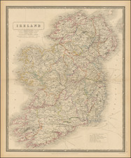
![[ Ireland ] Hiberniae Regnum tam in praecipuas Ultoniae, Connaciae, Lageniae, et Momoniae. . .](https://storage.googleapis.com/raremaps/img/small/78023.jpg)
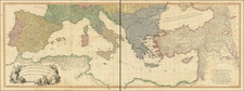
![[England, Scotland & Wales]. Parte Settentrionale del Regno d'Inghilterra . . . (with) Parte Meridionale del Regno d'Inghilterra . . .](https://storage.googleapis.com/raremaps/img/small/89516.jpg)
![[ British Islands ] Wight / Scilly / Jersey / Guernsey / Alderney / Man / Holy / Farne ] The Smaller Islands in the British Ocean](https://storage.googleapis.com/raremaps/img/small/98973.jpg)