![[Map of the World on a Globular Projection Exhibiting Particularly the Nautical Researches of Capn. James Cook, F.R.S. with all the Recent Discoveries to the Present Time carefully Drawn by A. Arrowsmith . . . ] By Aaron Arrowsmith](https://storage.googleapis.com/raremaps/img/small/94140.jpg)


|
||

|

|
|

|
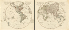
Rare early edition of Aaron Arrowsmith's double hemisphere world map.
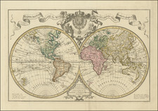
Arrowsmith's map of the World in two hemispheres was first issued in 1794 and was instrumental in establishing him in the London trade. Celebrating the discoveries of famed explorer James Cook, the map may fairly be described as the first truly scientific double hemisphere wall map of the world produced in English.
The map lays down the tracks of each of Cook's voyages, along with the discoveries of other circumnavigators and explorers (for example, discoveries by Mackenzie and Hearne in the Canadian Arctic).
The map is known in at least 4 states (1794, 1799, 1808 and 1814), along with unrecorded states, including an 1818 which we handled in 2018.
As is often the case, the present example is without the title and dedication which were printed on separate sheets and are sometimes are found trimmed and mounted onto the map when when joined as a single wall map. Stevens and Tree identify the above four issues based on the imprints; this copy without that information, but can be dated to the 1799 issue cartographically, i.e. with Bass Strait present and named between Australia and Tasmania, and with no indication of the Louisiana Purchase.
Dating The Map
Because not all examples of the map include the title and dating information, which were printed on separate sheets and are frequently lacking, dating the map has created confusion and a number of the institutional examples are mis-dated or otherwise catalogued in a misleading fashion.
The features which help to date this state of the map are:
- "Bass's Strait" is shown for the first time on a printed map -- as discovered by George Bass and Matthew Flinders in 1798. In the earlier editions, Nuyt's land appears in the middle of the southern coastline of Australia, but Bass's Strait is not present.
- Upper Missouri River System and Rocky Mountains based upon Humboldt are not yet shown (added in 1808).
- Large Lake and "Dogg Nation" appear in western North America (removed prior to 1808).
- Quadra & Vancouver Island is named (first shown in 1799).
The foregoing data points suggest that there may be 2 states of the map between the 1794 and 1808 editions (one with and one without the Bass Strait), rather than the 1 state noted by Stevens. We observe the following examples:
- 1794 - Boston Public Library: https://collections.leventhalmap.org/search/commonwealth:js956m40g
- 1799 - Lacking Bass Strait / JCB: https://jcb.lunaimaging.com/luna/servlet/detail/JCBMAPS~1~1~723~10055:-North-America-?qvq=q:globular%20projection&mi=7&trs=11
- 1799 - Naming Bass Strait / This Example
- 1808 - Stanford / Rumsey Collection: https://exhibits.stanford.edu/david-rumsey-map-collection/catalog/nd327vh1632
Aaron Arrowsmith
Aaron Arrowsmith was the founder of one of the leading London map publishing houses in the early part of the nineteenth century. He came to London about 1770 and worked as a surveyor for John Cary. In 1790, he set up shop in Long Acre and soon established an international reputation.
Aaron Arrowsmith, Hydrographer to the King of England and Geographer to the Prince of Wales, was the most influential and respected map publishers of the first quarter of the nineteenth century ... His role in cartographic production was to gather the best information available from a wide variety of sources, weigh the relative merits of conflicting data, and compile from this the most accurate depiction possible of an area. Arrowsmith accomplished this synthesis better than any other commercial map maker of his day and, as a result, his maps were the most sought after and highly prized on three continents"
(Martin & Martin, p. 113).
Arrowsmith specialized in monumental multi-sheet maps. Many of his maps are now very rare on the market.
The Arrowsmiths were a cartographic dynasty which operated from the late-eighteenth century to the mid-nineteenth. The family business was founded by Aaron Arrowsmith (1750-1823), who was renowned for carefully prepared and meticulously updated maps, globes, and charts. He created many maps that covered multiple sheets and which were massive in total size. His spare yet exacting style was recognized around the world and mapmakers from other countries, especially the young country of the United States, sought his maps and charts as exemplars for their own work.
Aaron Arrowsmith was born in County Durham in 1750. He came to London for work around 1770, where he found employment as a surveyor for the city’s mapmakers. By 1790, he had set up his own shop which specialized in general charts. Arrowsmith had five premises in his career, most of which were located on or near Soho Square, a neighborhood the led him to rub shoulders with the likes of Joseph Banks, the naturalist, and Matthew Flinders, the hydrographer.
Through his business ties and employment at the Hydrographic Office, Arrowsmith made other important relationships with Alexander Dalrymple, the Hudson’s Bay Company, and others entities. In 1810 he became Hydrographer to the Prince of Wales and, in 1820, Hydrographer to the King.
Aaron Arrowsmith died in 1823, whereby the business and title of Hydrographer to the King passed to his sons, Aaron and Samuel, and, later, his nephew, John. Aaron Jr. (1802-1854) was a founder member of the Royal Geographical Society (RGS) and left the family business in 1832; instead, he enrolled at Oxford to study to become a minister. Samuel (1805-1839) joined Aaron as a partner in the business and they traded together until Aaron left for the ministry. Samuel died at age 34 in 1839; his brother presided over his funeral. The remaining stock and copper plates were bought at auction by John Arrowsmith, their cousin.
John (1790-1873) operated his own independent business after his uncle, Aaron Arrowsmith Sr., died. After 1839, John moved into the Soho premises of his uncle and cousins. John enjoyed considerable recognition in the geography and exploration community. Like Aaron Jr., John was a founder member of the RGS and would serve as its unofficial cartographer for 43 years. Several geographical features in Australia and Canada are named after him. He carried the title Hydrographer to Queen Victoria. He died in 1873 and the majority of his stock was eventually bought by Edward Stanford, who co-founded Stanford’s map shop, which is still open in Covent Garden, London today.
![The Western Hemisphere... [with:] The Eastern Hemisphere A Stereographical Projection on the Twentieth Meridian](https://storage.googleapis.com/raremaps/img/small/97573.jpg)