|
||

|

|
|

|
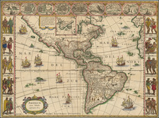
North American and Terra Incognita—A Curious Rarity
Rare and interesting map of America, with a massive unknown Northwest Coast of America and an unusual engraving style.
Although it was printed in the eighteenth century, it more closely resembles a woodcut in style, a method used mainly in the sixteenth century.
The map includes North and South America, with part of Europe to the east. Much of the Pacific is included in the western part of the map, and it is dotted with islands. The Atlantic includes the Azores, Canaries, Cape Verde Islands, and the Lucayan Archipelago, otherwise known as the Bahamas.
The political divisions of empires are marked with dotted lines. Virginia extends along the entire eastern seaboard, while Florida encompasses much of what is today the southern United States. In addition to European claims of American land, the Iroquois Confederacy is also recognized. In the west, Santa Fe, founded in 1598, is the only settlement labeled.
Many settlements are included in Mexico and South America, however, showing their earlier colonization by Spain and Portugal. Of particular note is Potosi; which by the time this map was published it was in decline, but in the mid-sixteenth century it had been the fourth largest city in the world.
In the Pacific, the only island labeled is the Solomon Islands. Although famous, in the early-eighteenth century Europeans were still unsure where the islands were located. The first European to contact the islands was Alvaro de Mendaña. He led a Spanish expedition to the Solomon Islands in 1567-9, but his crew forced his return to Peru. Another attempt was made from 1595-6 to return to the Solomons, but they had not been charted accurately. Mendaña died on Santa Cruz, which is not labeled here, leaving his wife in charge of the settlement they had started. She decided to return to Spanish dominions and they arrived in the Philippines in early 1596. The Solomons would not be accurately charted until the late-eighteenth century.
The most eye-catching part of this map is the massive coastline in the Pacific Northwest of North America. It is labeled as “Terra Esonis Incognita.” Esonis is a reference to Jesso, a feature included on many seventeenth and eighteenth-century maps. Historically, Eso (Jesso, Yedso, Yesso) refers to the island of Hokkaido, north of Japan. It varies on maps from a small island to a near-continent sized mass that stretches from Asia to Alaska. Here, in a creative flourish, the landmass is connected to North America, suggesting a further connection to Asia.
The map appeared in Wagner's Einleitung in die alte und neuere Geographia, published by Leopold Hodl and printed by Gregory Kurtzbock in Vienna. The work included a series of ancient maps and modern maps; this map was part of the latter.
The book was published in only a single edition and the maps from it are quite rare.
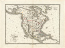
![[ Rare Group of American Maps Published in Prague ] Neueste Länder und Völkerkunde. Ein geographisches Lesebuch für alle Stände . . . Funfzenter Band America Mit Charten . . . 1818](https://storage.googleapis.com/raremaps/img/small/102973.jpg)