
The item illustrated and described below is sold, but we
have another example in stock. To view the example which
is currently being offered for sale, click the
"View Details" button below.


|
||

|

|
|

|
Stock# 64197
Description
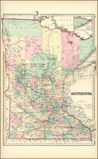
Detailed map of the state of Minnesota, colored by townships and showing counties, towns, rivers, canals, etc.
An excellent large format map of the period from one of the major American map publishers of the 1870s.
O.W. Gray Biography
O. W. Gray was a publishing firm based in Philadelphia. Later, they published as O. W. Gray & Son. They published atlases in the late nineteenth century. Gray's National Atlas was one of the most successful commercial ventures of the 1870s and one of the last to employ hand coloring on maps.
![(Chicago World's Fair & St. Paul, Minn.) [Contemporary album of 71 Photographs of St. Paul and Chicago World's Fair, Columbian Exposition]](https://storage.googleapis.com/raremaps/img/small/87334.jpg)
![[ Mille Lacs Lake, Minnesota ] Thomas W. Allison Milaca, Minn. Reference: The Security State Bank Princeton, Minn.](https://storage.googleapis.com/raremaps/img/small/101935.jpg)
![Diagram showing ceded and reserved Chippewa lands in Minnesota [with:] In the Supreme Court of the United States. October Term, 1912.](https://storage.googleapis.com/raremaps/img/small/93674.jpg)
![Bancroft Freeborn Co. MT [Minnesota Territory]](https://storage.googleapis.com/raremaps/img/small/82401.jpg)