|
||

|

|
|

|
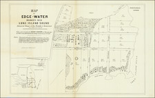
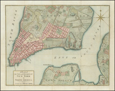
Rare cadastral map of New York City's Spanish Harlem.
A rare cadastral or property map of northeastern Manhattan, New York City, between Second Avenue and the Harlem River, and from 113th to 125th Streets. This area is today generally considered part of Spanish Harlem. The map employs color coding to define the limits of the former estates belonging to the Swiss-American Philip Milledoler (September 22, 1775 – September 22, 1852, 5th president of Rutgers College/University), William Wood (1777 - 1857, businessman), and Morris A. Randel.
Provenance
This map was acquired as a part of a large collection of New York cadastral maps associated with the layer Ronald K. Brown, a Deed Commissioner operating in the late 19th and early 20th century with an office at 76 Nassau Street, New York - not far from Holmes' own office. Most of the maps in the collection, including the present map, bear Brown's stamp on the verso. The maps were passed to Dominic Anthony Trotta, a real estate agent working under Brown. Brown seems to have ceased business around 1919, but Trotta continued as a real estate agent, becoming a New York Tax Commissioner in 1934 under the Fiorello H. La Guardia administration. The maps remained with Trotta's heirs until our acquisition of the collection.
Publication History and Census
This map was prepared by Amerman and Ford, former city surveyors acting in a private capacity. It was engraved and lithographed by Miller's Lithography, 137 Broadway. Extremely rare. We have identified only three other known examples, all part of institutional collections.