


|
||

|

|
|

|
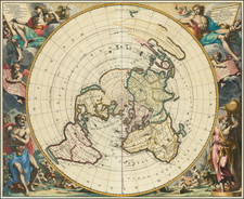
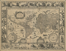
A Distinctive World Map on a Distinctive Projection
Fine example of Van der Aa’s planisphere, which is based on Cassini’s famed, massive 8-meter, astronomically-rendered world map, originally constructed on the floor of the Paris Observatory at the end of the 17th Century.
The map radiates from the North Pole, stretching the South Pole to infinity. The projection also emphasizes how clustered the world’s landmasses are in north, as there is no southern continent included.
While the chimera of a vast, temperate southern continent is not shown here, there are other mythical coastlines in several places. California is shown as an island, as it often was in the seventeenth and eighteenth centuries.
Greenland is speculatively connected across the North Pole to Iesso, a common feature on maps of this period (see below). However, this northern land is not connected to North America—there is still space for the much-desired Northwest Passage via the Strait of Anian (see below).
Australia, which is also labeled as New Holland after the initial Dutch encounters with the western shores, stretches far into the eastern Pacific. New Zealand and New Guinea also have hypothetical extensions, as their true extent was then unknown to Europeans.
This map is notable not only for its geography, but for its corner vignettes representing the seasons. In the upper left is a garlanded young god writing the title cartouche in French and representing spring. His summer counterpart, slightly older, is in the upper right, with the title cartouche in Latin. Below, the deity now has a beard and is holding the scales of Libra surrounded by the fruits of autumn. In the lower right are cold cherubs warming themselves with a fire in winter, with an old man Atlas in the foreground.
Cassini’s planisphere
The distinctive part of this map are the asterisks scattered across the map in 43 places. A cherub at the left explains that these are astronomically-derived geographic coordinates. This is a reduction of, and closely follows the geography of, the vaunted Cassini-Nolin map of 1696. The asterisks mark locations where latitude and longitude observations were made, making them anchor points for this innovative map.
At the turn of the eighteenth century, latitude could be derived, with some adjustments, by observing the altitude of the sun. There were several instruments that could help to accurately read this measurement, including the quadrant. Longitude can be derived from observing the satellites of Jupiter, but these observations could only could be accurately measured while on land. Finding longitude at sea was still an enigma, with many suggestions as to how to derive it with no concrete solutions—this would be the great scientific project of the eighteenth century.
The renowned cartographer Giovanni Domenico Cassini was concerned with the longitude problem, but also with trying to compile the most accurate map possible based on astronomical readings. To do so, he collected coordinate readings from correspondents of the Académie des Sciences, trusted scientific minds from around the world, and built his map up from that base. These included Edmond Halley’s observations at the Cape of Good Hope, as well as others at Quebec, Goa, Peking, and elsewhere.
The map itself, on an equidistant azimuthal projection, was laid out on the floor of one of the towers in the Paris Observatory. It was eight meters in diameter, a massive monument to astronomy and cartography—the first map to be derived from such an accurate and widespread set of astronomical data.
That grand map is lost to us, but a reduced version was drawn by Cassini’s son, Jacques, then a budding astronomer himself. The map was published by J. B. Nolin in 1696. Two states of the Nolin-Cassini map are known, each surviving in only a few examples.
This is the most decorative obtainable example of the Cassini planisphere.
This strait, believed to separate northwestern America from northeastern Asia, was related to the centuries-long quest to find a Northwest Passage connecting the Atlantic Ocean to the Pacific. The rumor of this strait and a Northwest Passage in general inspired many voyages of discovery, including those of John Cabot, Sir Francis Drake, Gaspar Corte-Real, Jacques Cartier, and Sir Humphrey Gilbert.
The term Anian itself comes from Marco Polo’s thirteenth-century accounts of his travels. Polo used the term to refer to the Gulf of Tonkin, but cartographers thought it could refer to this supposed strait between Asia and North America. The Strait of Anian, so named, first appeared in a 1562 map by Giacomo Gastaldi, and was later adopted by Bolognini Zaltieri and Gerard Mercator.
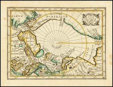
North Pacific chimeras: Yesso, De Gama, and Compagnie Land
The etymology of the idiom Yesso (Eso, Yeco, Jesso, Yedso) is most likely the Japanese Ezo-chi; a term used for the lands north of the island of Honshu. During the Edō period (1600-1886), it came to represent the ‘foreigners’ on the Kuril and Sakhalin islands. As European traders came into contact with the Japanese in the seventeenth century, the term was transferred onto European maps, where it was often associated with the island of Hokkaido. It varies on maps from a small island to a near-continent sized mass that stretches from Asia to Alaska.
The toponym held interest for Europeans because the island was supposedly tied to mythic riches. Father Francis Xavier (1506-1552), an early Jesuit missionary to Japan and China, related stories that immense silver mines were to be found on a secluded Japanese island; these stories were echoed in Spanish reports. The rumors became so tenacious and tantalizing that Abraham Ortelius included an island of silver north of Japan on his 1589 map of the Pacific.
Yesso is often tied to two other mythical North Pacific lands, Gamaland and Compagnies Land. Juan de Gama, the grandson of Vasco de Gama, was a Portuguese navigator who was accused of illegal trading with the Spanish in the East Indies. Gama fled and sailed from Macau to Japan in the later sixteenth century. He then struck out east, across the Pacific, and supposedly saw lands in the North Pacific. These lands were initially shown as small islands on Portuguese charts, but ballooned into a continent-sized landmass in later representations.
Several voyagers sought out these chimerical islands, including the Dutchmen Matthijs Hendrickszoon Quast in 1639 and Maarten Gerritszoon Vries in 1643. Compagnies Land, often shown along with Staten Land, were islands sighted by Vries on his 1643 voyage. He named the islands for the Dutch States General (Staten Land) and for the Dutch East India Company (VOC) (Compagnies, or Company’s Land). In reality, he had re-discovered two of the Kuril Islands. However, other mapmakers latched onto Compagnies Land in particular, enlarging and merging it with Yesso and/or Gamaland.
In the mid-eighteenth century, Vitus Bering, a Danish explorer in Russian employ, and later James Cook would both check the area and find nothing. La Perouse also sought the huge islands, but found only the Kurils, putting to rest the myth of the continent-sized dream lands.
Pieter van der Aa (1659-1733) was a Dutch mapmaker and publisher who printed pirated editions of foreign bestsellers and illustrated books, but is best known for his voluminous output of maps and atlases. Van der Aa was born to a German stonecutter from Holstein. Interestingly, all three van der Aa sons came to be involved in the printing business. Hildebrand was a copper engraver and Boudewyn was a printer.

![[Arctic Sea] Mari Archipelaghi polari artici Dalla Baia D'Hudson all America Russa](https://storage.googleapis.com/raremaps/img/small/65899.jpg)