|
||

|

|
|

|
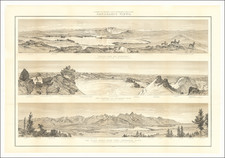
The First American Atlas Map of the Transmississippi West -- Based Upon Lewis & Clark's Reports
Nice example of the rare second state of Mathew Carey's highly important map of Missouri Territory.
Published shortly after the return of Lewis & Clark, Mathew Carey's map of the Transmississippi West is one of the seminal maps of the period and the first atlas map to provide the cartographic detail derived from the return of the Lewis & Clark expedition. The map was first issued in 1814, the same year Lewis & Clark issued their highly influential map of the region from the Missouri River to the Pacific Ocean, which was also issued by Matthew Carey. It is, without question, the first great map of the American West to appear in a Commercial Atlas published in the United States.
Carey's map is a curious amalgam of information. While it includes highly up to date Lewis & Clark geographical details in certain portions of the map, other portions continue to rely upon Soulard and earlier material furnished by Lewis.
Stretching from the Mississippi and Missory (sic) Rivers and the Atlantic Ocean, Carey's Missouri Territory . . . and John Melish's map of the United States represent landmarks in American Cartographic history. Each look for the first time, to explain the vast tracks of land obtained by Jefferson in the Louisiana Purchase, and begin to reconcile the information then being provided by Arrowsmith, Lewis & Clark, Humboldt and other sources.
States of the Map
There are two states of the map:
- First State: The place name St. Louis shown east of the Mississippi River
- Second State (1818): The place name St. Louis moved to the west of the Mississippi River, with an erasure of the old location still present.
An essential map of Western American Collectors.
![[ California To Alaska -- Northwest Passage ] Quivirae Regnu cum alijs versus Borea](https://storage.googleapis.com/raremaps/img/small/60083.jpg)