
This item has been sold, but you can enter your email address to be notified if another example becomes available.


|
||

|

|
|

|
Stock# 64037
Description
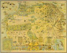
Presentation Copy! -- One of the Earliest Maps of San Francisco published in the City.
Finely detailed map of the populated areas of San Francisco, oriented to the west. The map extends west to Divisadero; south to Alta.
The present example is overprinted, to show distances at quarter mile intervals from Portsmouth Square and also includes numbered and lettered lots.
One interesting feature is the tracing of the original shoreline of San Francisco, showing just how much of the city is built on landfill.
The present example is accompanied by a presentation copy of the San Francisco Municipal Reports for the Fiscal Year 1861-62, given to E.C. Kennedy.
Rarity
The map is quite rare on the market.
![[ Spanish Flu -- Masks -- Armistance Day WWI ] The Unveiling of The Kaiser's Finish By Capt. J.F. Mora At Pittsburg, Calif, Nov 17th, 1918.](https://storage.googleapis.com/raremaps/img/small/99630.jpg)
![[Berkeley] This Is The Map of Berkeley Town Its Streets Go Winding Up & Down An Oak-Covered Campus It Wears For A Crown With People & Places of Renown](https://storage.googleapis.com/raremaps/img/small/97201.jpg)
![[ Sunol, California ] Res. & Farm of Duerr & Nusbaumer, Sunol., & T.F. Bachelder's Ranch, Alameda County, California](https://storage.googleapis.com/raremaps/img/small/102044.jpg)