This item has been sold, but you can enter your email address to be notified if another example becomes available.


|
||

|

|
|

|
Stock# 63901
Description
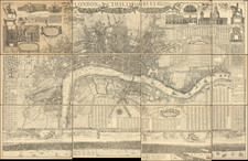
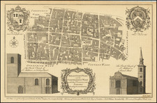
Detailed antique map of central London by Thomas Tegg, published in London in circa 1810.
The map names almost all of the streets in central London at the time and shows the city in the middle of the Georgian Era, before the massive building booms and expansion of the city would occur later in the 19th century.
Tegg makes sure to mention in the title that the map shows the East and West India Docks.
Condition Description
Trimmed close at right edge.
Reference
Howgego 258
![[ Saxon London ] The City of London, in the Time of the Saxons (about Year 1000.) Compiled from the most authentic Documents.](https://storage.googleapis.com/raremaps/img/small/98224.jpg)