|
||

|

|
|

|
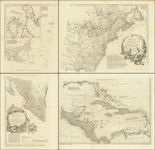
Striking Map of North America Based on De L’Isle’s Foundational Map of North America
Lotter’s rendition of De L'Isle's highly important map of North America (1700), which was the first map to correctly place the mouth of the Mississippi and to return California to a peninsular form. Here it is re-engraved, but with similar geographic details to the original.
De L'Isle's map of North America is a widely celebrated cartographic landmark. De L'Isle had access to the latest information from French explorers in the New World, during a time when the French dominated the exploration of the interior of the continent.
While his first regional maps did not appear until 1703 (Carte du Mexique et de la Floride... and Carte du Canada ou de la Nouvelle France) and 1718 (Carte de la Louisiane et du cours de Mississipi.... ), this map represents De L'Isle's first work on North America. It was extremely influential for other maps of the period, as evidenced by Lotter’s reissuing of his version of the map, both for what it includes and as a snapshot of the knowledge available to De L'Isle in the three years immediately prior to his issuing of the regional maps.
The map is intensely detailed, although areas that lack information are boldly left blank. In addition to settlements, rivers, forts, and mountains, De L’Isle has included numerous notes about geographic features and local peoples.
The Great Lakes, based on Coronelli, show the French strongholds at Tadousac, Quebec, Fort Sorel, Montreal, and Fort Frontenac. The English settlements are kept to the east of the Alleghenies, with Fort and River Kinibeki as the border between New England and Acadia.
Lotter has switched the cartouches in the upper right corner, choosing a vignette showing a European navigator with his ship and trade goods, which is contrasted to an African man offering a plate of food. Lotter also includes a less ornate scale and text box in the upper left corner; the note and the annotations across the map have been translated from French to Latin.
The Mississippi River Valley and states of this map
De L’Isle’s was a map of firsts, including being the first to show the Sargasso Sea (Mer de Sargasse). The most significant first, however, is the earliest correct placement of the mouth of the Mississippi River on a printed map. Here, Lotter has followed De L’Isle closely, only adding an additional outlet to the sea, creating a small delta island at the mouth of the river.
According to previous cartobibliography, the map considered the first state includes the cartographer's address as "Rue de Canettes" in the cartouche; the second state has the address of “Quai de l’Horloge.” However, an article in the Map Collector (Issue 26, pp. 2-6, March 1984) by Schwartz and Taliaferro describes a copy located in Austria of an earlier state in which the mouth of the Mississippi River is shown in Texas, rather than, as on the later states, in Louisiana, slightly west of longitude 280º. The earlier state is known in only a very few examples.
The lower portion of the Mississippi River is angled differently than Cassini’s efforts. Farther upriver, this was the first map to separate the Wabash from the Ohio River, showing the former as a tributary of the latter. This is also one of the earliest maps to show the Louisiana expeditions led by Pierre Le Moyne d’Iberville (1698-1699).
Early in his career, D’Iberville explored Hudson Bay, and harassed the Hudson’s Bay Company, on behalf of the Compagnie du Nord. After the Sieur de la Salle travelled from the Great Lakes to the Gulf of Mexico via the Mississippi River in 1682, d’Iberville was tasked by the Minister for Naval Affairs and Colonies, Pontchartrain, to locate the mouth of the river.
D’Iberville left Brest in October 1698 with four ships. He sailed along the Gulf Coast, past the new Spanish fortifications at Pensacola, shown on this map, and arrived at the Birdfoot Delta in March 1699. Thanks to native informants, he found that this was indeed the river he was looking for.
D’Iberville set out again the following year. He sailed this time to Biloxi. He also returned in 1701, after this map was initially published by De L’Isle, to build at fort at Mobile. In 1718, his brother, Jean-Baptiste Le Moyne de Bienville founded New Orleans.
The island of California
One of the most noted aspects of De L'Isle's map is that it is considered the first map to revert to the treatment of California as a peninsula. However, it is more accurate to say that this map shows De L’Isle’s evolving thoughts on California, reproduced here by Lotter. Careful examination shows that the Californie and Nouveau Mexique do not meet, and the coast north of C. Mendocin is left blank. Such calculated, conservative depictions highlight De L’Isle’s skill and mark this map as a crucial linchpin in the re-evaluation of the geography of California from the late-seventeenth to mid-eighteenth centuries.
From its first portrayal on a printed map by Diego Gutiérrez, in 1562, California was shown as part of North America by mapmakers, including Gerardus Mercator and Ortelius. In the 1620s, however, it began to appear as an island in several sources, including Samuel Purchas’ Hakluytus Posthumus or Purchas his Pilgrimes (1625).
This was most likely the result of a reading of the travel account of Sebastian Vizcaino, who had been sent north up the shore of California in 1602. A Carmelite friar who accompanied him described the land as an island and sketched maps to that effect. Normally, this information would have been reviewed and locked in the Spanish repository, the Casa de la Contractación, but the ship carrying the map and other Vizcaino documents was captured by the Dutch. Prominent practitioners like John Speed, Jans Jansson, and Nicolas Sanson adopted the new island and the practice became commonplace. Even after Father Eusebio Kino published a map based on his travels refuting the claim (Paris, 1705), the island remained a fixture until the mid-eighteenth century.
This is not to imply that all mapmakers were blindly accepting of the convention. In 1700, roughly the same time this map was initially produced, De L’Isle discussed “whether California is an Island or a part of the continent” with J. D. Cassini; the letter was published in 1715. After reviewing all the literature available to him in Paris, De L’Isle concluded that the captured Spanish map was not trustworthy, as other Spanish maps showed California as a peninsula. He also cited more recent explorations by the Jesuits (including Kino) that disproved the island theory.
He concludes:
On my maps and globes I have taken the precaution of representing the coast as cut and interrupted in this place, as much on the side of Cape Mendocino as on the side of the Red Sea. I have left in these two places as though stepping stones during an interrupted work, and I have not believed it necessary to make up any mind about a thing which is still so uncertain; therefore I have made California neither an Island nor a part of the Continent, and I will stay with this point of view until I have seen something more positive than I have seen to date. (quoted from translation in Polk, 316)
This description precisely describes California as shown on this map, and marks this map as an important declaration of De L’Isle’s broader cartographic philosophy. Later, in his map of 1722 (Carte d’Amerique dressee pour l’usage du Roy), De L’Isle would abandon the island theory entirely. However, his contemporaries and successors, including his son-in-law, Philippe Buache, remained adherents to the island depiction for some time.
Tobias Conrad Lotter (1717-1777) is one of the best-known German mapmakers of the eighteenth century. He engraved many of the maps published by Matthaus Seutter, to whose daughter Lotter was married. He took over Seutter’s business in 1756. Lotter’s son, M. A. Lotter, succeeded his father in the business.

![[Fruit Crate Label Advertising Map] Panama Brand (North America & Panama Canal)](https://storage.googleapis.com/raremaps/img/small/48860.jpg)