|
||

|

|
|

|
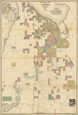
One of the Earliest Surviving Maps of Fidalgo Island
Rare map of Fidalgo Island, named after the Spanish explorer and cartographer Salvador Fidalgo who explored the area in 1790.
The map is color coded to show the lands owned by several different land owners, with the names at the right, showing lands acquired in the northwestern part of the island and on Burrows Island shaded by land owners.
Fidalgo Island
The modern history of Fidalgo Island begins with the Fraser River gold rush of 1858, when the first permanent settlers, Charles W. Beale, his cousin Robert and a party of four others built a cabin on what is now known as March Point. Among those in the Beale party was Lt. Robert H. Davis, nephew of Jefferson Davis, future president of the Confederacy.
The next settler of note was William Bonner, who sold his property rights in December 1869 to William Munks. Many settlers followed. Almina Richards Griffin, wife of John T. Griffin, is credited with being the first white woman to live on the island. She and her husband arrived from Whatcom in the late 1860s. By the early Seventies, settlement on the island was permanent.
Practically all the government land was taken by 1873, with semi-weekly communication by steamer to the island. The island included two stores, two blacksmith shops, a wheelwright’s shop, a post office and a public school. Much of the development of the Seventies was due to speculation that the island would be selected as the terminus of the Northern Pacific Railroad. Extensive holdings along the shore of Ship Harbor were secured by Hazard Stephens, son of Governor Isaac I. Stevens.
Rarity
We locate no other surviving examples.
![[Washington] Map of West Okanogan Valley Irrigation District](https://storage.googleapis.com/raremaps/img/small/89722.jpg)