


|
||

|

|
|

|
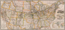
Exceptional map of the United States, on of the earliest maps to show country from coast to coast.
Following on the mapping of the Northwest by Lewis & Clark and John Melish's landmark map of the United States from coast to coast published in 1819, Tardieu's map is one of the first to incorporate this information, with notable additions.
Tardieu's map includes significantly more topographical detail in the Pacific Northwest, improving the course of the Columbia River, adding a number of lakes and generally improving the course and detail of the rivers west of the Rocky Mountains. The map would seem to incorporate a considerable amount of information available from the Hudson Bay Company and fur traders in the region which was not included by Melish or Lewis & Clark.
Texas is identified as "Province de Texas" A massive Michigan Territory extends to the Mississippi River, incorporating the lands which would become Minnesota and Wisconsin.
Pierre Alexandre Tardieu (1756-1844) was a French engraver.
Tardieu was a member of the Institut de France, the Saint Petersburg Academy and the Academy of Milan.
His students included Auguste Gaspard Louis Desnoyers.

![[HAPAG Map of the United States and Canada]](https://storage.googleapis.com/raremaps/img/small/78779.jpg)
![(Extremely Rare American View Book) Les Ports de l'Amerique [8 engraved prints of American Cities: Philadelphia, Boston, Savannah, Fredericksburg, Charlestown, Chesapeake Bay, Quebec, and Port Royal] Graveé d'apres le Tableau de Vernet.](https://storage.googleapis.com/raremaps/img/small/95381.jpg)