|
||

|

|
|

|
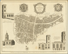
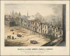
George Vertue's Edition of a London Rarity -- The Leake Map
Nice example of George Vertue's magnificent engraving on two sheets of the destruction in London after the Great Fire of 1666.
The map extends from Fetter Lane to Tower Dock, focusing on the damage caused by the fire. Eight insets, including:
- St. Paul's Cathedral (south view and west view)
- Baynard's Castle
- Royal Exchange
- Cheapside and the Cross
- Old Buildings near the Temple Gate Fleet Street
- South Front of the Guild Hall
- Plan of the City of London and Westminster with a reference table.
Vertue likely copied this work directly from from John Leake's original map of 1667 (engraved by Wencelaus Hollar). The map shows the extent of the Great Fire, marking the buildings lost to the flames, with pre-fire elevations of some of the buildings.
The Leake Map
In 1660, Wenceslaus Hollar produced an engraved version of John Leake's monumental map of post-fire London. As noted by Michael Hunter:
The map is significant not only for its graphic illustration of the destruction wrought by the Great Fire but also for the accurate surveying underlying its production. On two plates, it was pubished by the stationer Nathanael Brooke and sold at Gresham College. It exists in two states; the first which is very rare (found in the Fitzwilliam Museum, Cambridge) is dated 1667 and carries the names Sir William Bolton, the Lord Mayor; the second state is dated 1669 nd the name of the new mayor, Sir William Turner, is added.
The technical surveying behind the map was the work of six people, all of a mathematical and scientific inclination, who were named and acknowledged on the print. The include William Leybourne, author of the Compleat Surveyor (1653), and Richard Shortgrave, Hooke's colleague at Gresham College, where he was operator to the Royal Society. The other surveyors were John Leake, John Jennings, Wiliam Marr and Thomas Streete. The map referred to in the title as "first described in six plats by John Leake . . . made in December 1666," is lost. nevertheless, a large manuscript map is extant, dated January-March 1667, reduced by Leake into "one intire plat", which must have formed the basis of Hollar's print.
![The Heart of London [in:] Map to the Heart of London with the Compliments of MEA](https://storage.googleapis.com/raremaps/img/small/97705.jpg)