|
||

|

|
|

|
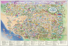
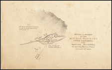
Enjoy Your Vacation on Uncle Sam's Free Automobile Campgrounds
Rare promotional map of California published by the U.S. Forestry Service, encouraging camping in California's National Forests, advertising the availabililty of "maps and detailed information" from the District Forester in San Francisco or any Forest Supervisor.
The map shows the National Forests in Yellow, Automobile Roads in red, with arrows pointing to the free public campgrounds.
The Office of the District Forester was located at 114 Sansome Street until about 1917. From 1915-1919, the Forestry Service promoted a flurry of camping and recreational maps, which were available from the District Forester.
The map notes that it is photographed from the N.F. Drake Relief Map at Stanford University. Noah Fields Drake constructed his relief map in 1896. An article by Drake entitled The Topography of California in The Journal of Geology, Vol. 5, No. 6 (Sep. - Oct., 1897), pp. 563-578, describes the making of the relief map, etc.
The N.F. Drake Relief map seems to have been photographed a fair amount in the early part of the 20th Century and seems to have been a work of great importance: The following note appeared in the 1923 U.S.G.S. publication Hydroelectric Power Systems of California and Their Extensions Into Oregon and Nevada (p. 12)
Several relief maps of California and the neighboring territory have been made. A large model, which gives a good idea of the general features of the region, is now in the exhibit of the California Development Board in the Ferry Building, San Francisco. The best detailed relief map of California is one made by Mr. N. F. Drake and now in the museum of the department of geology at .Stanford University. It is from this map that Plate I of this report was prepared. Certain extensions have been made in railway lines since the map was constructed, but these changes do not, of course, affect the value of the map for topographic study; it is to-day the most accurate and thorough map of its kind.
The following notes appears in the 1908 Annual Report of the Library Department of the City of Los Angeles (p. 57)
A notable accession to the Reference room this year was Drake’s Relief map of California, 5 x 6 feet. This was made under the direction of Vice President J. C. Branner, of Stanford University, the most distinguished geologist in the West, and is one of the three extant copies. It is under plate glass on a special table. The use of maps of all sorts in this library is astonishingly large; and we are endeavoring, with fair success, to meet the demand. The Document department now has 1762 maps; besides the 64 more general ones in the Reference department.
Rarity
The map is unrecorded. We find no examples in OCLC or in any other reference source.