|
||

|

|
|

|
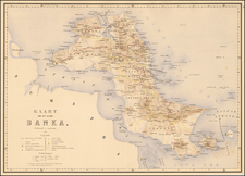
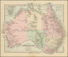
Rare separately published map of Australia and the Indian Ocean published Sayer & Bennett in London in 1780.
Rare English sea chart, which appeared in the first edition of the ‘East-India Pilot, or Oriental Navigator," a landmark in the history of British Sea Atlases of East Asia. The sea chart incorporates the work of the latest map makers such as Alexander Dalrymple and d’Apres de Mannevillette. Examples of the atlas extremely rare and when seen are usually black and white; this example is in magnificent early wash colour and printed on superb thick paper.
The map takes in not only the whole Indian Ocean but extends from Korea and Japan in the north, south to include the whole of Australia. The latter still too early to depict Bass Strait with ‘Tasmania’ but does record Captain James Cook’s arrival there in 1770. ‘Great Bay’ notes Botany Bay. Although many errors were perpetuated here. To the north ‘New Guinea’ and ‘Papua’ are illustrated as two independent islands. Despite this error it is the first map to name the Torres Strait.
Australian Cartography
The map illustrates Australia following the explorations of Captain James Cook in the region, but prior the arrival of the First Fleet, which placed a colony in the Botany Bay area in January 1788 and prior to Matthew Flinders' discovery of Bass Strait, separating Van Diemen's Land (Tasmania) from the mainland of Australia a decade later.
The map shows the "Gulf of Corea"
Rarity
A very fine example of a chart we are unable to trace a record of on the market for since 1988. The National Library of Australia only holds 1/2 of this important map.
Provenance: Susanna Fisher, 1988; private English collection (Reeman Dansie Sale 2019). Owned jointly with Clive A. Burden Ltd.
Thomas Jefferys (ca. 1719-1771) was a prolific map publisher, engraver, and cartographer based in London. His father was a cutler, but Jefferys was apprenticed to Emanuel Bowen, a prominent mapmaker and engraver. He was made free of the Merchant Taylors’ Company in 1744, although two earlier maps bearing his name have been identified.
Jefferys had several collaborators and partners throughout his career. His first atlas, The Small English Atlas, was published with Thomas Kitchin in 1748-9. Later, he worked with Robert Sayer on A General Topography of North America (1768); Sayer also published posthumous collections with Jefferys' contributions including The American Atlas, The North-American Pilot, and The West-India Atlas.
Jefferys was the Geographer to Frederick Prince of Wales and, from 1760, to King George III. Thanks especially to opportunities offered by the Seven Years' War, he is best known today for his maps of North America, and for his central place in the map trade—he not only sold maps commercially, but also imported the latest materials and had ties to several government bodies for whom he produced materials.
Upon his death in 1771, his workshop passed to his partner, William Faden, and his son, Thomas Jr. However, Jefferys had gone bankrupt in 1766 and some of his plates were bought by Robert Sayer (see above). Sayer, who had partnered in the past with Philip Overton (d. 1751), specialized in (re)publishing maps. In 1770, he partnered with John Bennett and many Jefferys maps were republished by the duo.
![Tabula Asiae XI [India and Southeast Asia]](https://storage.googleapis.com/raremaps/img/small/94323.jpg)