


|
||

|

|
|

|
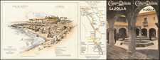
Exceptional, Colossal Map of La Jolla.
The present map, published in 1924, is the earliest detailed map of La Jolla and the largest map of the area we have seen. The map also extends south to Mission Bay and shows all of Pacific Beach including Crown Point.
The map is noteworthy for its early representations of La Jolla in plot-level detail, with streets, subdivisions, and additions labeled. Much of the development shown on this map, even in the Village of La Jolla, would be substantially changed and expanded over the coming decades, and almost no maps remain of the area in this early configuration.
Outside of the first iterations of the Muirlands and La Jolla Country Club Heights neighborhoods, there is no real development on Mount Soledad. Bates Addition, at the south end of Mount Soledad is labeled "Abandoned" and was never physically laid out.
A number of La Jolla landmarks are shown, including:
- Scripps Pier (then the "Biological Station")
- Gold Fish Point
- Alligator Head
- Mammoth Caves
- Rocky Point
- Seal Rock
- Shell Beach
- Whale View Point
The San Diego Electric Railway is shown running through Pacific Beach from Mission Beach, to what is now the La Jolla bike path, and to Fay Avenue where it ends at Prospect.
Rarity
We can locate no other copies of this map in institutional collections, sales databases, nor through Google searches.

![Map of the City of San Diego and Vicinity [cover title:] Street Map of San Diego](https://storage.googleapis.com/raremaps/img/small/77116.jpg)