


|
||

|

|
|

|
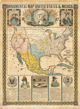
Rare Early Depiction of "Minesota" Territory
Decorative map of the United States, published during the Mexican War.
Of particular note, the map is one of the earliest printed maps to show Minnesota Territory (called "Minesota" on the map), which would not become a territory until March 3, 1849.
The map includes a large Oregon Territory, with the area to the northwest claimed by the United States in British Columbia identified. Massive Nebraska Territory, Minnesota Territory, Utah Territory, New Mexico Territory and Indian Territory. The map highlights the "Route of the Oregon Emigrants."
The map is surmounted by portraits of George Washington, General Zachary Taylor and General Winfield Scott, with views of the Great Temple of the Sun (Mexico), an early sidewheeler and "The Halls of Montezuma."
Across the top is a panorama of the "Contemplated Oregon Railroad." At each side is a short vignette on each of the states of the Union.
![[Hand Drawn Map] Le Golfe de Mexique avec les Pays Circonvoisins](https://storage.googleapis.com/raremaps/img/small/91580.jpg)