|
||

|

|
|

|
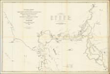
Mapping The Water Project That Made Los Angeles
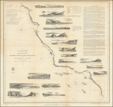
Fine large format map of the course of the Los Angeles Aqueduct from February 1908.
The map presents a remarkable overview of the Los Angeles Aqueduct system in the first month of construction. Superimposed over a detailed topographical map of the Central part of the state, the map extends from the Los Angeles Basin to Mono County and the south end of Mono Lake, including the Long Valley Reservoir, Yosemite National Park and Mammoth Lakes.
At the lower right, a Key to Index System explains the divisions responsible for construction of the Aqueduct, including 11 sections of the aqueduct, a Railroad, Cement Works, Power Plants and other logistical support.
The present example of the map was used by the Pacific Electric Railway and extra illustrated at an early date, adding a Legend at the lower left, identifying the major railroad lines whose lands were impacted by the Aqueduct, including:
- Southern Pacific RR Co. (red)
- Atchison Topeka & Santa Fe Ry (yellow)
- San Pedro, Los Angeles & Salt Lake RR Co (green)
- Pacific Electric Ry Co (black)
- Visalia Electric RR Co (scarlet lake)
The present example was previously in the collection of the Pacific Electric Railway Company, which was discarded in the 1970s.
Other Early Maps of The Los Angeles Aqueduct
In researching this map, the only other map of the Aqueduct which we could confirm to have been published in 1908 is a much reduced and simplified map entitled "Map of the Los Angeles Aqueduct and adjacent territory", published in October 1908.
It is possible that a precursor to this map may have been issued in 1906 by N. Boweditch Blunt with a slightly different title, "Topographic map showing the Owens River region and route of the proposed Los Angeles Aqueduct." There exists a copyright entry for this map in the name of "N. Bowditch Blunt." The size of the map suggests that it may be the same map. The Los Angeles Public Library may hold an example of the map (but at a much reduced size) and UC Berkeley lists ownership of a photocopy of the map.
Nathaniel Bowditch Blunt is the name of a famous chartmaker, but this blunt died in 1896 in New England. Interestingly, the June 11, 1913 Los Angeles Herald notes that
N. Bowditch Blunt of Los Angeles has the unenviable distinction of being the first man ever convicted In the United States for violation of the copyright act. He was found guilty today by a Jury in the federal court of Infringing on the copyright of Laura L. Whitlock to a transportation map of Los Angeles.
Charles H. Lee likely produced a set of maps in 1909 and 1910 described as "Map of drainage and evaporating areas,' (which survive in a single photocopy set at UC Riverside) which were listed as
- In the Bishop-Big Pine region west of Owens River (Dec. 1910)
- In the Long Valley region (Nov. 1909)
- In the Independence region west of Owens River (Dec. 1910).
To date, we have been unable to confirm the survival of an original of the 1906 map or any other maps prior to 1910.
The Los Angeles Aqueduct
At the end of the 19th Century, Los Angeles County suffered the effects of limited local water supplies and a severe drought. Recognizing the importance of securing a reliable water source, Through the end of the 19th century, a private corporation called the Los Angeles City Water Company controlled for the city’s water supply system. In 1902, the municipal government bought the franchise, retaining the City Water Company’s superintendent, William Mulholland, as head of the new Los Angeles Department of Water and Power. Mulholland, a self-trained engineer born in Ireland, had begun his career as a ditch-cleaner for the water company and risen to become its superintendent at the age of 31.
In 1904, the Board authorized Mulholland and several other engineers to find possible new water sources that would meet the city’s needs. With the help of his former boss Fred Eaton, Mulholland identified a potential solution in the Owens Valley region, located on the eastern side of the Sierra Nevada some 200 miles away. The engineers estimated that the Owens River, which ran through this region, could provide more than enough water to meet the needs of a growing Los Angeles.
The residents living in Owens Valley had plans of their own for the Owens River and were seeking federal funding from the Bureau of Reclamation for a public irrigation project in the region. By the end of 1905, however, Eaton and Mulholland were able (using Eaton’s extensive political contacts, as well as dubious tactics such as bribery and deception) to acquire enough land and water rights in Owens Valley to block the irrigation project.
Mulholland and Eaton planned to route the aqueduct from the Owens River straight into the San Fernando Valley, an arid region of land nearby the city. A syndicate of Los Angeles businessmen (including Harrison Gray Otis, publisher of The Los Angeles Times, and railroad magnates Moses Sherman, E.H. Harriman and Henry Huntington) had been buying up acres of land in the San Fernando Valley, and stood to gain tremendously once the aqueduct provided water for the arid region. With the backing of such powerful players, the $1.5 million bond issue necessary to begin the aqueduct’s construction passed overwhelmingly in 1905. Further ensuring the draining of Owens Valley, the aqueduct project had also earned the support of President Theodore Roosevelt, who considered it an ideal example of his Progressive agenda for the nation.
Construction began in 1908 and was divided into eleven divisions and a cement plant. The number of workers who were on the payroll the first year was 2,629 and this number peaked at 6,060 in May 1909. In 1910, employment dropped to 1,150 due to financial reasons but rebounded later in the year. Between 1911 and 1912 employment ranged from 2,800 to 3,800 workers. The number of laborers working on the aqueduct at its peak was 3,900. In 1913 the City of Los Angeles completed construction of the first Los Angeles Aqueduct.
The construction of the Los Angeles Aqueduct effectively eliminated the Owens Valley as a viable farming community and eventually devastated the Owens Lake ecosystem.
Although there is disagreement over the actions of the "syndicate" as to whether they were a "diabolical" cabal or only a group that united the Los Angeles business community behind supporting the aqueduct, Eaton, Mulholland and others connected with the project have long been accused of using deceptive tactics and underhanded methods to obtain water rights and block the Bureau of Reclamation from building water infrastructure for the residents in Owens Valley.
By the 1920s, the aggressive pursuits of the water rights and the diversion of the Owens River precipitated the outbreak of violence. In 1924 and again in 1927, protesters blew up parts of the aqueduct, marking a particularly explosive chapter in the so-called “water wars” that had divided Southern California.
Tragedy struck in 1928, when the St. Francis Dam in northern Los Angeles County burst, inundating the towns of Castaic Junction, Fillmore, Bardsdale and Piru with billions of gallons of water and drowning hundreds of residents. An investigation concluded that the rock in the area had been too unstable to support the dam. Though Mulholland was cleared of charges in connection with the incident, his reputation was ruined, and he was forced to resign. The Los Angeles Aqueduct was extended further north by the early 1940s through the Mono Basin Project, finally reaching a total length of 338 miles.
Rarity
The map is very rare. We locate only the example in the Library of Congress dated February 1908, but lacking the railroad legend and utilizing a different color scheme, which focuses on the aqueduct line only.
OCLC also locates photocopies of the February 1908 edition of the map at UCLA and UC Berkeley.
![[Limited Edition of 33] The Sculpture & Art of Jo Mora](https://storage.googleapis.com/raremaps/img/small/94900.jpg)