|
||

|

|
|

|
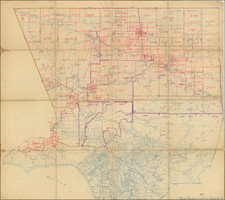
Fine early plan of San Pedro, surveyed shortly after it became the official port of Los Angeles.
The map covers most of modern San Pedro, including what was then called the Palos Verdes Tract, Esperanza Tract No. 1 and No.2, Rudecinda Tract, and Carolina Tract, extending from the US Military Reservation in the southwest corner to the Los Angeles River (with a bridge crossing the river).
Within the map, the Plaza, School House and San Pedro Lumber Company seem to be the only places identified, with the US Reservation, Banning Company, Kerckhoff Cuzner Lumber Co. and Boschke Island noted outside of the city limits. Later annotations allso the add the Breakwater, Southern Pacific Depot, Los Angeles T. RR Depot, Ferry and other details.
The map is drawn by Charles T. Healey, and important early Los Angeles Surveyor, who served as surveyor for both San Pedro and Long Beach in the 1870s. Healey includes a note that "My original surveys embrace the territory lying east of West Street and South of Santa Cruz Street Only. Outside Subdivisions by other Surveyors. Dec. 29th, 1898." Notes in the top right corner indicate that the map was revised in January and February of 1899.
At the top left, the maker records notes on dozens of early Los Angeles Subdivisions. inlcuding the Carolina, Palos Verdes, and San Pedro tracts.
The present example is believed to have been part of the archives of the Southern Pacific Railroad until the 1970s, when it was discarded.
San Pedro
San Pedro's modern history begins with Phineas Banning, known as "the Father of the Port of Los Angeles." Banning arrived in San Pedro, California, in 1851. At the time, San Pedro was a small fishing village of San Pedro, just south of the Pueblo of Los Angeles.
Banning soon began his own staging and shipping company. By the 1860s, Banning wagons were traveling to Salt Lake City, the Kern River gold fields, the new military installation at Yuma, Arizona, the Mormon settlement at San Bernardino and in an arc around the Southern California region.
The harbor and docks at San Pedro began as illegal exchange sites for mission contraband during the Spanish and Mexican eras. Banning was the first to expand these original sites and make them efficient enterprises. In the late 1850s Banning and a group of Southern California investors purchased 640 acres of land adjacent to San Pedro for port expansion. The land purchase was incorporated as Wilmington, with the port becoming known as Banning's Landing.
Banning invested the profits from his trade networks into the development of a more sophisticated port complex and for the creation of roads, telegraphs, and other connections to Los Angeles. In 1859, the first ocean-going vessel anchored in Los Angeles-Wilmington harbor and the 1860s saw the beginning of small-scale maritime trade between San Pedro and ships anchored in the deeper parts of the harbor. After government-funded dredging made a deep water harbor and breakwater a reality, the port continued to grow.
In the late 1860s, Banning began construction of Southern California's first railroad, the Los Angeles & San Pedro Railroad which he sold to the Southern Pacific Railroad in 1873. As a California state senator, Banning prioritized creation of greater transportation connections to Los Angeles and San Pedro. Banning eventually pushed through a plan for a small railroad linking Wilmington/San Pedro with the main city of Los Angeles, effectively halving the time necessary for the trip but the plan was short-lived. The Southern Pacific Railroad began building track to connect Southern California to the greater national railroad lines and demanded much of Los Angeles' prime real estate, an enormous sum of money and Banning's small connector line railroad, in exchange for adding Los Angeles as a terminus on the railroad. Realizing that Los Angeles would wither into nothingness if the company bypassed it, the city complied and Banning surrendered his hard-earned railroad.
In 1873, the first breakwater was built. In 1888, the US War Department took control of a tract of land next to the bay and added to it in 1897. The efforts to develop the port as the official port of Los Angeles came to fruition in 1897, when Congressman Stephen M. White pushed through legislation that made San Pedro the official port of Los Angeles.
Rarity
The map is unrecorded.
Regarded as one of the giants of early California Surveyors, Charles T. Healey was educated at Perkinsville Academy, and began his career as a surveyor at a very early age.
Healey spent time in New York before going to California in 1854, where he arrived first in San Jose. He was employed as city clerk in San Jose from 1856 to 1858 and city engineer from 1862 to1866, during which time he received the rank of Captain as part of his role in the home guard of San Jose. He also served as county surveyor of Santa Clara county from 1856 to 1858. Healey also was the mining engineer of two quicksilver mines, the New Almaden and the Guadalupe, near San Jose.
During Healey's years in the area, it was said that he surveyed every Spanish land grant south of San Jose, California.
Healey began doing survey work in Southern California by the 1870s, when he was was invited by Jotham Bixby to survey the Rancho Los Cerritos, which included laying out a townsite that would eventually become Long Beach. This work would lead to his becoming the the first resident and surveyor for Willmore City, which would shortly thereafter be renamed as Long Beach, California.
Healey was the first licensed surveyor in California, following the creation of the California licensing provisions by the California Business & Professions Code, holding license number 1 granted by the State on July 20, 1891.
He has been recognized as one of "the giants of the land surveying profession."