|
||

|

|
|

|
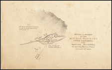
Early example of the first plan of Wilmington, surveyed by Frank Lecouvreur, who served as Los Angeles City Surveyor in 1868-69.
The present map shows the first town plan of Wilmington, shortly after its creation. Included in the map are the Drum Barracks, given to the US Government during the American Civil War, the land reserved to Phineas Banning, its original owner and promoter, and the names of its six owners:
- Phineas Banning
- B.D. Wilson
- J.P. McFarland
- H.R. Myles
- Manuel Dominguez
Each of the town blocks and larger 20 acre lots and 111 acre lots are divided equally among the 6 owners.
Wilmington History
The Port of Los Angeles district of Wilmington was included in the 1784 Spanish land grant of Rancho San Pedro. Phineas Banning acquired the land that would become Wilmington from Manuel Dominguez, heir of the original concession holder Juan Jose Dominguez, in 1858 to build a harbor for the city of Los Angeles. Known as New San Pedro from 1858 to 1863, it was subsequently renamed Wilmington by Banning after his birthplace, Wilmington, Delaware.
In 1861, at the beginning of the Civil War, Banning and Benjamin Wilson gave the federal government 60 acres of land to build Drum Barracks to protect the nascent Los Angeles harbor from Confederate attack.
Wilmington was a township in the 1870 census. The township consisted of the present-day South Bay communities, Compton and western Long Beach, with a population of 942 in 1870.
![(Southern California - Oxnard to Glendale) [Composite of Eight Topographical Maps]](https://storage.googleapis.com/raremaps/img/small/95921.jpg)
![[ Orange County / Wine Industry ] Residence of Theodore Reiser, Anaheim, Los Angeles Co., Cal.](https://storage.googleapis.com/raremaps/img/small/96403.jpg)