|
||

|

|
|

|
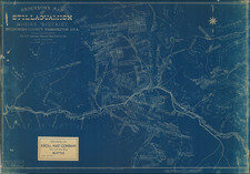
Port Townsend During the Boom of the 1890s
Rare separately published map of Port Townsend and the Quimper Peninsula region, published by W.H. Whitney and Miller & Going.
The map covers the mouth of the Straits of Juan de Fuca, Port Discovery, Port Townsend Bay, Scow Bay or Long Harbor and the western edge of Whidbey Island.
The larger inset shows the route of the Union Pacific Railroad line from Port Angelos to Port Townsend and south to Union City.
The map notes the routes of the following:
- Port Townsend Electric Railway
- Port Townsend Steam Motor
- Mount Olympus Water Co. Pipe Line
- Railroads
- Wagon Roads
Several dozen subdivisions and additions are shown in color. A note in red pen locates a 437.06 acres of land on Cape George, drawn in an early hand.
Rarity
The map is very rare. We note only a single example for sale in a dealer catalog in the past 30 years.
![(Native American Portrait) Man-ce-muckt [Watercolor of Mancemuckt, Chief of the Indians of the Dalles of the Columbia River (i.e. Chief of the Skeen), after Paul Kane]](https://storage.googleapis.com/raremaps/img/small/95030.jpg)
![Pacific Coast Highways Canada to Mexico [Texaco Tour Maps Routes and Mileages Canada to Mexico]](https://storage.googleapis.com/raremaps/img/small/91594.jpg)