


|
||

|

|
|

|
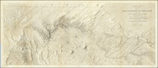
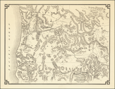
The First Map Printed in Seattle -- Seattle & Walla Walla Railroad Map With Manuscript Corrections Likely In the Hand of the Maker
Fine example of this rare map of the Pacific Northwest, illustrating the proposed route of the Seattle & Walla Walla Railroad, which was intended for publication with an 1874 promotional pamphlet entitled Report of the Chief Engineer of the Seattle and Walla Walla Railroad and Transportation Company.
The present example was issued separately and never bound into the pamphlet. While a few examples survive in the pamphlet, we note only 1 separately published map in the Washington State Library.
Following Seattle's losing out as the terminus of the Northern Pacific Railroad, the town fathers scrambled to create an alternative railroad line to the east, leading to the establishment of the Seattle & Walla Walla. While the line was partially built, it never received much enthusiasm from Walla Walla and was ultimately acquired by Henry Villard's Oregon Improvement Company in 1880. It was renamed the Columbia and Puget Sound Railroad.
The map focuses on the route of the Seattle & Walla Wall Railroad, extending from Seattle to Walla Walla, then connecting to the proposed Portland, Dallas & Salt Lake Railroad at Walla Walla. This line in turn extends to Salt Lake City via Fort Boise and Boise City. The line passes to the north of the Owyhee mines, south of the Snake River and Fort Boise. The focal point of the map is the elaborate depiction of the regional topography and the railroad lines and rivers in the region and several early roads.
In their cataloging of this map, Washington State University mentions the impetus for the founding of the Seattle & Walla Walla Railroad and the publication of the map:
When the Northern Pacific selected Tacoma as the western terminus for its transcontinental route in 1873, Seattle residents took matters into their own hands. The city of Seattle incorporated its own railway, the Seattle and Walla Walla Railroad, with the express intent of building its own route over the Snoqualmie pass and across Washington to Walla Walla. The Railroad never made it to Snoqualmie Pass, much less to Walla Walla. It did make it up the valley as far as Renton (in 1877) and Newcastle (in 1878), at which point it became primarily a coal railroad, transporting enormous quantities of coal down from the Newcastle mines to the Seattle docks at a greatly reduced transport cost. The Seattle and Walla Walla Railroad was purchased by the Columbia and Puget Sound Railroad in 1881.
The location of Priest Rapids is added on the Columbia River, with the word "and" also added to the title in manuscript, strongly suggesting that this was a proof copy of the map.
The pamphlet sets for a proposal for a narrow-gauge railroad crossing the Cascades and connecting the cities of Seattle and Walla Walla. The standard bibliographies call references two maps, neither of which was apparently bound into the pamphlet on a consistent basis. The present map, titled, "Map of Washington Territory and Oregon with portions of adjoining Territories with the Route of the Seattle & Walla Walla Rail Road," and a map city of the City of Seattle, the first printed map of the City, with a number of towns appearing in Montana and Idaho.
As noted by Thomas W. Streeter in the Streeter Sale Catalog (1968):
This is the first Seattle imprint recorded in the AII, Washington. Though it is the second railroad project recorded there, the first, printed in Walla Walla in 1871, was only a local enterprise, while this is the first printing in Washington for a railroad project crossing the Cascades. The report is based in part upon the surveys for the Northern Pacific Railroad which were made available to Mr. Morris. Alternate routes are also discussed. A narrow gauge road is proposed which it was estimated would cost less than four million dollars and result in large profits. A. A. Denny of Seattle was president of the enterprise.---TWS.
The catalog entry for the Soliday copy, sold in 1945 to Streeter, notes:
Smith 3562 locates only the copy at the University of Washington. Aside from its bibliographical interest as undoubtedly the first book printed in Seattle, this work takes the lead in the early propagandising of the “Seattle Spirit” which in time was to make Seattle the great city of the Northwest
Rarity
The pamphlet and map are extremely rare. We are aware of only a single example offered at auction with the Washington map (PBA Galleries in 2011), which include the note that the pamphlet was rare "with no copies having appeared at auction since the Streeter sale in 1968."
This is the first time we have ever seen the map, which was acquired in a small group, unfolded, each with the same corrections in pen as noted above.