


|
||

|

|
|

|
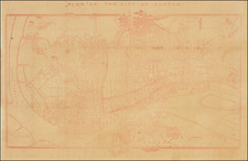
Rare First State James Wyld's Important Chart of the = Pearl River Delta -- Hong Kong, Canton (Guangzhou) and Macau
Wyld's map of the region is one of the earliest broadly accurate maps of the area .
Issued in September 1840, during the early period of the First Opium War (1839-42), the map appeared four months before the British gained possession of Hong Kong. The map was one of the first commercially published maps available to British forces as they planned major military expeditions against Chinese positions in the region, eventually taking over Hong Kong.
The map covers the full Canton (Guangzhou)-Hong Kong-Macau triangle, with a level of detail and accuracy previously not obtainable. The map details the locations of cities, towns, villages, key mountains and headlands, as well as labelling forts, pagodas, fishing stakes, and rice fields, while the seas and rivers feature copious bathymetric soundings, the labelling of hazards, as well as information on anchorages, tides and shipping routes. The map also features various interesting notes on the nature of the country and its settlements. While many areas are very precisely defined, some stretches are completely uncharted.
‘Hong-Kong Id.’ appears in the lower-right center,, shown as sparsely settled isle of small Chinese fishing villages, with numerous cites to drawing ‘Water’ are labelled along the shores. ‘Ty-tam Bay’ (Tai Tam Bay) is noted, while the island’s western-most point, by today’s Mount Davis, is labelled as ‘Fish[in]g Boat Cr[eek]’. Across the harbor is ‘Cow-loon’ (Kowloon), then a sizable Chinese town protected by ’20 G[u]ns’. ‘Lan-tao Id.’ (Lantau Island) is noted as being a ‘Great Habitable Country’ populated by many fishing villages.
To the west, across the mouth of the Pearl River, is Macao, a Portuguese colony since 1557. Canton, with its ‘European Factories’ appears at the head of the Pearl River estuary.
On the right side of the map is a ‘Plan of the City of Canton’, detailing the ‘Old’ and ‘New City’, with it labyrinths of streets, labelling all key sites such as European factories, temples, hospitals, colleges, as well as major Chinese governmental and military offices.
The map incorporates the best nautical surveys of the East India Company officer Captain Daniel Ross who spent thirteen years charting the coasts of southern China between 1806 and 1820; with his mapping of the areas around Hong Kong in 1810 and 1815 being particularly notable. The map also features information derived from updated editions of John William Norie’s excellent New Chart of the Coast of China from Pedra Branca to St. John's Island Exhibiting the Entrance to and Course of the River Tigris (first published in 1817, but since improved).
The present map is the first state of what became a regularly updated map series produced by Wyld. This edition is the only issue to predate the British acquisition of Hong Kong, which occurred on January 26, 1841. Wyld’s second state of the map, likely issued in September 1841, updates the scene accordingly, plus adding military information concerning the ongoing First Opium War, as can be seen upon the American Geographic Society’s example held at the University of Wisconsin-Madison:
https://collections.lib.uwm.edu/digital/collection/agdm/id/5845/rec/1
Wyld followed up with an 1842 edition with further updates the picture, particularly concerning Hong Kong Island, as well as adding further military information, as can be seen upon the example held by the University of Minnesota Library:
https://geodata.mit.edu/catalog/de9b12dc-0ad0-4af8-a2d4-f69a321c0a92
Wyld apparently issued subsequent editions of the map, in 1847 and 1855, although we have not been able to view examples of these issues.
Rarity
The first state of the map is extremely rare, with no auction records in the past 30 years. OCLC locates 2 copies (British Library and the Cornell University Library).
We locate a single example of a later 1842 edition of the map in a 2008 dealer catalog.
James Wyld Sr. (1790-1836) was a British cartographer and one of Europe’s leading mapmakers. He made many contributions to cartography, including the introduction of lithography into map printing in 1812.
William Faden, another celebrated cartographer, passed down his mapmaking business to Wyld in 1823. The quality and quantity of Faden’s maps, combined with Wyld’s considerable skill, brought Wyld great prestige.
Wyld was named geographer to Kings George IV and William IV, as well as HRH the Duke of York. In 1825, he was elected an Associate of the Institution of Civil Engineers. He was one of the founding members of the Royal Geographical Society in 1830. Also in 1830, his son, James Wyld Jr., took over his publishing house. Wyld Sr. died of overwork on October 14, 1836.
James Wyld Jr. (1812-87) was a renowned cartographer in his own right and he successfully carried on his father’s business. He gained the title of Geographer to the Queen and H.R.H. Prince Albert. Punch (1850) described him in humorous cartographic terms, “If Mr. Wyld’s brain should be ever discovered (we will be bound he has a Map of it inside his hat), we should like to have a peep at it, for we have a suspicion that the two hemispheres must be printed, varnished, and glazed, exactly like a pair of globes.”
![[First Obtainable Map to Name California] Tartariae Sive Magni Chami Regni typus](https://storage.googleapis.com/raremaps/img/small/82510.jpg)
![[Ladrone Islands / Wanshan Archipelago] Ladronen Chine](https://storage.googleapis.com/raremaps/img/small/90221.jpg)
![[ Southern Hainan Coast ] A Chart of the South Coast of Haynan from Tinhosa to Guichou](https://storage.googleapis.com/raremaps/img/small/94735.jpg)
![Province de Chen-Si [Shaanxi Province]](https://storage.googleapis.com/raremaps/img/small/95545.jpg)