


|
||

|

|
|

|
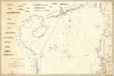
Rare separately pubished sea chart of a portion of the Philippine Islands, published in Madrid by the Spanish Hydrographial Survey.
The map extends from the south part of Luzon Island in the north to the northern part of Panay and Leite, tracking the Straits of San Bernardino.
A fine example of this scarce chart, which was first issued in 1869 and revised in 1870.
The Dirección de Hidrografía, or the Directorate of Hydrographic Works, was established in 1797. Its roots were in the Casa de Contratación, founded in 1503 in Sevilla, which housed all the charts of the Spanish Empire and oversaw the creation and maintenance of the padrón real, the official master chart. The Casa, now in Cadiz, was shuttered in 1790, but Spain still needed a hydrographic body. In response, the Dirección was created in 1797. One of its first projects was the publication of charts from the Malaspina Expedition (1789-1794). The Dirección oversaw not only publication, but also surveying. The Dirección was abolished in the early twentieth century, when their work was distributed to other organizations.
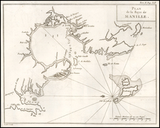
![[Manila Bay] La Baie de Manille, Selon les Observations les plus recentes . . .](https://storage.googleapis.com/raremaps/img/small/59286.jpg)

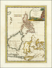
![[Southeast Asia, Philippines & India] Nova Delineatio particularis Apostolicarum Peregrinationum noni Indiarum Apostoli in India Orientali](https://storage.googleapis.com/raremaps/img/small/51679.jpg)