|
||

|

|
|

|
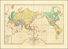
Very Rare Six-Sheet Map of the World from The Golden Age of Dutch Cartography -- Updated with Sir Edmund Halley's Explorations in the Southern Hemisphere
Frederick de Wit’s exceptional six-sheet map of the world—this is only the third known example of the map, published by Reiner & Joshua Ottens in Amsterdam.
A remarkable survival in exceptional condition for a wall map of this age, the world map was intended for display on the walls of salons, dining rooms, and libraries of European aristocrats. The map outlines the major discoveries of the circumnavigators and other world explorers from the sixteenth and seventeenth centuries, including Magellan, Tasman, Mendaña and Le Maire.
The map shows the world in two hemispheres. Additionally, a double hemisphere celestial map is tucked between the larger hemispheres at the top, while a double hemisphere polar projection is nestled into the bottom of the map.
The map’s title is simple and located outside the frame of the map itself. The border of the map, however, is elaborately decorated. Similar to the decorations on his second wall map of the world, ca. 1670, each corner houses its own vignette that combines a season with zodiac symbols.
- Spring is in the upper left, surrounded with nature’s bounty and a bull, referencing the zodiac sign of Taurus. The ram of Aries is in the background, while the female figure carries the twins of Gemini at her hip.
- Summer, in the upper right, brings in the harvest. A lion (Leo) helps, while a cherub carries the crab (or lobster) of Cancer. The virgin, Virgo, sits in the background, watching.
- Autumn, in the lower left, shows a bacchanal with men, carried by satyrs, drinking to excess; one is being sick on the ground. The attendant cherubs carry scales (Libra) and a scorpion (Scorpio). A centaur hunts to the right, a reference to Sagittarius.
- Old Man Winter braves a harsh landscape; one of his minions holds two fish, a reference to Pisces. Another cherub pours water, serving as the water bearer of Aquarius. Others drag a goat between them (Capricorn).
Between the hemispheres are further vignettes. Four cherubs huddle above the conjunction of the two main hemispheres, decked out with symbols of nature and faith. Below the main hemispheres are four women, representative of the four continents: Asia, America, Europe, and Africa.
The Ottens state of the map
The map is remarkable not just for its size and decorative qualities; it would also appear to be the most cartographically-advanced example of De Wit's wall maps of the world. Over the course of his career, in the second half of the seventeenth century, De Wit published several of the largest and most important wall maps of the world. These maps are now prized for their beauty and rarity.
This is the second-known state of De Wit’s final wall map of the world, first produced in ca. 1680. This second state of the six-sheet map, only the second known example of its kind, includes Edmund Halley's voyages in the South Atlantic. This state likely dates from ca. 1720, although it could be from slightly earlier.
As compared to De Wit’s wall map of the world, ca. 1660, there are significant additions including changing the name of Sinus Persicus to "G de Balsera" (the Arabian Sea). Other major changes can be seen throughout the map including:
- Five Great Lakes are shown, rather than one.
- The shape of the Philippines is significantly improved.
- Terra Esonis (land bridge in North Pacific) is added.
- Nova Guinea, Quiri Regio, and the Solomon Islands area all added in the west Pacific.
- The location of Van Diemen's Land (Tasmania) is moved east.
- The configuration of Hudson Bay, Button's Bay, Baffin Bay and Davis Strait are all improved.
- The coast of China, Southeast Asia, and Korea are all improved.
- The configuration of the Caspian Sea is improved.
- The shape of the Arabian Peninsula and Gulf of Balsera (Arabian Sea) are significantly improved.
- The shape of Madagascar is improved.
- The shape of India, Sri Lanka and the Gulf of Bengal are greatly improved, along with the Ganges and its sources.
- Even the coastlines of Great Britain are significantly updated.
As noted above, a remarkable element of this second state of the map is its additions of the explorations of Sir Edmund Halley, following Halley's explorations in the Southern Hemisphere between 1698 and 1700, which were not present on any earlier De Wit maps.
In his exhaustive study of world maps published prior to 1700, Rodney Shirley located two surviving examples of this map (British Library and University of Amsterdam). The British Library copy would appear to be a proof or first state, as it lacks some engraved areas in the decorative elements at the center of the map and there is no imprint at the bottom center. This was likely reworked by de Wit himself, with the imprint and the Halley information, with the ships’ tracks, added later.
In the present example and the Amsterdam example, there are two notable cartographic additions. First, the routes of over a dozen explorers are noted, including Magellan, Tasman, Mendaña and Le Maire, and, quite remarkably, Edmund Halley. In addition, a land mass has been added in the Antarctic Regions, south of Africa and near to Halley’s track. This coastline was not present in the earlier British Library example.
Sir Edmund Halley, his voyages, and mountains of ice
Edmund Halley (ca. 1656-1742) was one of Britain’s foremost astronomers and natural philosophers. He was also an explorer and mapmaker famous for his voyages to study magnetic variation. Halley began his astronomical observations as a schoolboy at St. Paul’s School and later at Queen’s College, Oxford. By the time he left Oxford, he had already written three scientific papers and was in touch with the foremost minds in Europe, including the architect Christopher Wren, the natural philosopher Robert Hooke, and fellow astronomers, John Flamsteed, Jean Dominique Cassini, and Johann Hevelius.
Halley left Oxford without a degree because he wanted to travel to St. Helena to determine the positions of the southern stars and to observe the Transit of Mercury, a project he embarked on with the support of Charles II and the East India Company. Although not entirely successful, the star chart he published as a result earned him Fellowship in the Royal Society. In 1680, Halley and a school friend embarked on a scientific Grand Tour of Europe, observing the first appearance of a bright comet.
He discussed this comet with Isaac Newton upon his return. Halley struck up a great friendship with Newton and oversaw the publication of Newton’s masterpiece, Philosphiae naturalis principia mathematica (1687). Halley wrote the Latin preface to the work, the most important in the field of physics ever published.
In the 1680s, Halley became interested in magnetic variation. As part of these studies, he produced one of his first known maps, a chart of the trade winds, the first such meteorological chart of its kind. To gather more data on the worldwide phenomena, Halley gathered information about winds and magnetic variation from a global network and took to the sea himself to make surveys and observations. In 1689 he presented a chart of the Thames approaches to the Royal Society. In 1691, he improved the design of a diving bell to help with the salvage of a cargo of gold and ivory.
Halley’s interest in sailing and charting continued in the 1690s, even as he worked as warden to the county mint at Chester. He published a flurry of scientific papers in this decade on topics including life expectancy, optics, rainbows, thermometers, and barometers. Most influential of his work for this time, he calculated the orbit of 24 comets and concluded that comets like the one he saw while on the Grand Tour have elliptical orbits. He also explained that the comet of 1682 had a return period of roughly 75 years; this comet was later named for Halley.
In 1698, Halley was given command of the purpose-built Royal Naval ship the Paramore. He set sail for the South Atlantic to make observations of magnetic variation. He embarked on a second cruise in 1699, also to the South Atlantic. These two voyages served as the basis for a chart of magnetic variation that covered the entire Atlantic, the first to use isogonic lines and one of the first thematic charts ever produced. In 1701, Halley took the Paramore on a final cruise in the English Channel, which resulted in another chart that was a vast improvement on previous Channel charts.
Upon outbreak of the War of Spanish Succession, Halley was charged with surveying on behalf of England, a role which took him to the Adriatic. After completing his work there, he returned to an appointment as Savilian Professor of Geometry at Oxford. One of his major projects while there was to publish Flamsteed’s star charts, a project which contributed to the already stormy relationship between the men. In 1715, Halley drew a map of totality for a rare solar eclipse that would pass through London; his observations were still being used by astronomers in the twentieth century. In 1721, he succeeded Flamsteed as the second Astronomer Royal and moved to Greenwich, where he was concerned with the saronic cycle of the moon and, as ever, comets. He died there in 1742.
Edmund Halley's contribution to an understanding of Antarctic waters began with his discovery while in the Paramore of the Antarctic Circumpolar Current (ACC), the largest wind-driven current on Earth. It is the only current that goes all the way around our planet and connects the Atlantic, Pacific, and Indian Oceans. the ACC is driven by strong westerly winds and creates some of the roughest seas in the world; they are notorious to sailors.
He not only made scientific breakthroughs, but was also the first to extensively sail in the southern Atlantic, seeing mountains of ice, i.e. icebergs, en route. These mountains of ice could account for the additional coastline shown on this map.
Other voyages included on the second state
Many other ships’ tracks are included on this state of the map than just Halley’s South Atlantic voyages. These include:
- Columbus (1492). Christopher Columbus, the Genoese explorer credited with discovering the Americas on behalf of Spain, has a single track on this map, a compilation of his four voyages (1492-1504).
- Magellan (1519-1522). Ferdinand Magellan completed the world’s first circumnavigation while in the service of the Spanish Crown (he was Portuguese). Although he died in the Philippines, some of his crew managed to return to Spain.
- Gaetano (1542). Juan Gaetano (here written as Gaetani) was a pilot on a cross-Pacific voyage commanded by Ruy López de Villalobos which left Acapulco in 1542. They sighted and encountered several islands including, according to some, Hawai’i.
- Drake (1579). Francis Drake completed the first English circumnavigation of the world in 1577-1580. He sailed farther up the west coast of North America than any previous explorer, making it to northern California or Oregon (the exact location is still in dispute). As this was the most innovative part of the voyage, it is the only portion of his track included on this map.
- Mendaña (1568, 1595). Alvaro de Mendaña led a Spanish expedition to the Solomon Islands in 1567-9, but his crew forced his return to Peru. His pilot on this voyage was Hernando Gallego, and his name is mentioned along with Mendaña’s on this map. Another attempt was made from 1595-6 to return to the Solomons, but they had not been charted accurately. Mendaña died on Santa Cruz, leaving his wife in charge of the settlement they had started. She decided to return to Spanish dominions and they arrived in the Philippines in early 1596.
- De Gama (1588-90). João de Gama, the grandson of Vasco de Gama, was a Portuguese navigator who was accused of illegal trading with the Spanish in the East Indies. Gama fled and sailed from Macau to Japan. He then struck out east, across the Pacific, and supposedly saw lands in the North Pacific. These lands were initially shown as small islands on Portuguese charts, but they ballooned into a continent-sized landmass in later representations like this one. Several voyagers sought out de Gama’s lands, including the Dutchmen Matthijs Hendrickszoon Quast in 1639 and Maarten Gerritszoon Vries in 1643. Compagnies Land, was supposedly sighted by Vries on his 1643 voyage. He named the island for the Dutch East India Company (VOC) (Compagnies, or Company’s Land). In reality, he had re-discovered one of the Kuril Islands. However, other mapmakers latched onto Compagnies Land in particular, enlarging and merging it with Yesso and/or Gamaland, which was the island of Hokkaido. This confusion is reflected here.
- Van Heemskerck (1596-7). Jacon van Heemskerck (here written as Heemskerku) sought the Northeast Passage beginning in 1596, accompanied by Willem Barentsz as pilot. They discovered what they called Spitsbergen, which is now known as Svalbard. Their ship became locked in the ice and they were forced to winter in situ, the first time a ship had done so. In the spring, they escaped in open boats; Barentsz died, but van Heemskerck made it to the coast of Lapland.
- Van Noort (1598). Olivier van Noort led a squadron of four ships from Rotterman with plans to raid Spanish settlements in the Pacific. He lost two ships in the Pacific, but managed to return to the Netherlands, completing the first Dutch circumnavigation of the earth (1598-1601).
- Quiros (1606). Pedro Fernandez de Quiros (here written as Quiroi) accompanied Mendaña on his second voyage and was a skilled pilot. After returning to Spain, he convinced authorities that he could find Terra Australis, the southern continent, if they gave him ships and supplies. He set out in 1605 and eventually landed in Vanuatu. He mistook one of the islands for the fabled continent and called is Austrialia de Espiritu Santo (here Quiri Regio). Quiros intended to set up a colony, but his crew forced him to leave. Quiros returned to Mexico, but his second-in-command sailed west, through the strait now bearing his name. Due to state secrecy, however, the strait remained a secret until the 1760s.
- Hudson (1610-11). Henry Hudson initially sought the Northeast Passage in 1607 and 1608. In 1609, he tried the Northwest Passage, and he sailed up the Hudson River. He discovered the Hudson Strait and Hudson Bay on his next voyage, in 1610-11. That would be his last voyage; his crew mutinied and set him, along with his son and seven crew members, adrift in a shallop. They were never heard from again.
- Spilbergen (1614-1617). Spilbergen led a raiding voyage to the East Indies through the Straits of Magellan, eventually completing a circumnavigation.
- Le Maire and Schouten (1616) (here written as le Mairii). Isaac Le Maire and Willem Schouten led a circumnavigation that intended to break the monopoly over navigation via the Straits of Magellan held by the Dutch East India Company (VOC). They skirted the coast of Tierra del Fuego and found a strait between that network of islands and Staten Land, an island. This new way into the Pacific Ocean was lauded as a major coup for exploration and gained the voyage enduring fame.
- Tasman (1642). Abel Tasman was another Dutch explorer who was sent to see if there were possibilities of wealth and riches in the southwestern Pacific beyond Van Diemen’s Land (Tasmania). He was the first European to encounter New Zealand.
In all, the map is an exceptional example of the cartographic art, intended for display and the projection of learning and refinement at the dawn of the Age of Enlightenment.
Rarity
The map was previously known to survive in only two places – the British Library (BL K.4 .11.8 TAB END) and the University of Amsterdam (UBA W.B .001). Shirley notes that the British Library copy does not include the Ottens imprint, while the University of Amsterdam example has the same imprint as the present example.
The Ottens brothers, Reiner and Joshua, operated a successful printing partnership in the mid-eighteenth century (fl. 1726-1765). They began the venture in 1726, publishing maps and other prints as “R & I Ottens.” They specialized in the reprinting of others’ work, especially Guillaume De L’Isle. In 1750, Reiner died; his soon, also Reiner, took his place, but the firm began listing their works as “Joshua & Reiner Ottens.” The firm lasted until Joshua’s death in 1765. Joshua’s widow, Johanna de Lindt, sold their remaining stock of plates in 1784.
De Wit (1629 ca.-1706) was a mapmaker and mapseller who was born in Gouda but who worked and died in Amsterdam. He moved to the city in 1648, where he opened a printing operation under the name of The Three Crabs; later, he changed the name of his shop to The White Chart. From the 1660s onward, he published atlases with a variety of maps; he is best known for these atlases and his Dutch town maps. After Frederik’s death in 1706, his wife Maria ran the shop for four years before selling it. Their son, Franciscus, was a stockfish merchant and had no interest in the map shop. At the auction to liquidate the de Wit stock, most of the plates went to Pieter Mortier, whose firm eventually became Covens & Mortier, one of the biggest cartography houses of the eighteenth century.
![[ World ] Air France -- Sur Les Ailes D'Air France Decouvrez Le Monde A Votre Tour](https://storage.googleapis.com/raremaps/img/small/100053.jpg)