|
||

|

|
|

|
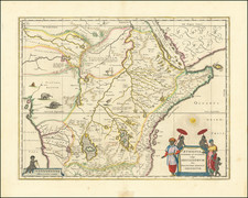
Fine early map of Northern Uganda,Lake Albert and the southern part of South Sudan, published as part of a Petermann & Hassenstein's map of Inner Africa.
The map features a number of roads and the routes of 19th Century African explorers, including:
- Speke & Grant, 1862 & 1863
- Ferdinand Werne - 1840-41
- d'Arnaud - 1840-41
- I Knoblocher - 1849-50
- Brun-Rollet & Angelo Vinco - 1848-51
- J. Peterick - 1858
- Jules Poncet - 1860
- F. Morlang - 1859-60
- Miani - 1860
- Antinori - 1860-61
- Peney - 1860
- G. Lejean - 1860
- W. von Hanier - 1860-61
- Th. von Heuglin - 1861-63
A highly detailed map of a region which is rarely treated with such detail.
August Heinrich Petermann (1822-1878) is a renowned German cartographer of the nineteenth century. Petermann studied cartography at the Geographical Art-School in Potsdam before traveling to Edinburgh to work with Dr. A. Keith Johnston on an English edition of Berghaus’ Physical Atlas. Two years later he moved to London, where he made maps and advised exploratory expeditions as they set off to explore the interior of Africa and the Arctic.
In 1854, Petermann returned to Germany to be Director of the Geographical Institute of Justus Perthes in Gotha. There, he was the editor of the Geographische Mittheilungen and Stieler’s Handatlas. The Royal Geographical Society of London awarded him their Gold Medal in 1860. He continued his interest in exploration in Germany, fundraising for the German Exploring Expeditions of 1868 and 1869-70, which sought an open Arctic sea. Tragically, he committed suicide in 1878.
![[Luanda, Angola] Eroberung der Statt Loando de Sanct Paolo in Angola in Africa. Gelegen](https://storage.googleapis.com/raremaps/img/small/85194.jpg)