This item has been sold, but you can enter your email address to be notified if another example becomes available.


|
||

|

|
|

|
Stock# 63629jc
Description
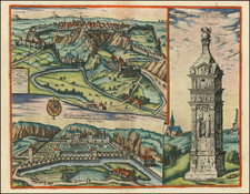
Finely executed manuscript map of Luxembourg City, after a printed map by Guillaume Danet, which was published in Paris in 1734. This map was probably executed around the same time and we date it circa 1734-1750.
In the traditional mid-18th-century French military mapping style, the map focuses on the structures of fortifications, blocks of buildings, and topography.
The plan includes a key locating 39 points of interest within the fortifications.
Danet's printed plan is quite rare; we have had it only once in over 25 years.
Condition Description
Manuscript in pen and ink with wash color. Even tape stains on the outer margins of the map, easily matted out. Otherwise Very Good +.