The item illustrated and described below is sold, but we
have another example in stock. To view the example which
is currently being offered for sale, click the
"View Details" button below.


|
||

|

|
|

|
Stock# 63500
Description
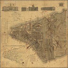
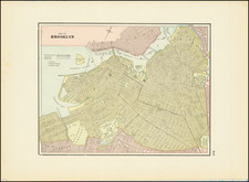
Interesting map of NYC and vicinity oriented with north at the top (most other double page maps of New York from this era are oriented with east at the top).
Shows parks, streets, wards, buildings, rail lines, wharfs, and many other features. Inset of Upper NYC and part of Westchester County. Also shows much of Brooklyn, Hoboken and Jersey City.
A nice large format map.
![[Brooklyn] Manhattan Beach Estates - Map of Property situated in the Borough of Brooklyn](https://storage.googleapis.com/raremaps/img/small/80730.jpg)