


|
||

|

|
|

|
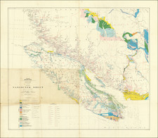
The Full Repeal of California's First Environmental Law
Highly interesting report and map that were prepared for the California legislature in 1927 and represent the effective end of the ban on hydraulic mining in California. This contentious water rights and environmental issue had been the subject of intense debate since the 1880s, but this ended due to lobbying pressure in the 1920s, as recommended in this report.
While hydraulic mining is most widely associated with California gold diggings, low-pressure forms had existed since Roman times, as still visible in Spanish landscapes and described by Pliny in his Naturalis. In the Californian Sierra Nevada, however, the use of Hydraulic mining in the 1850s to 80s was highly destructive, leading to massive flooding in the Central Valley. These recurrent and damaging floods, caused by rivers overladen with sediment, resulted in a number of deaths and prevented the use of large amounts of farmland.
The 1884 landmark environmental law banned the use of hydraulic mining. Prior to this, it was responsible for an average of 10 million dollars of gold production annually and a large industry, but, subsequently, the industry collapsed. However, unsurprisingly, the mining interests never stopped fighting. The federal government enacted a bill in 1893 that required California to enact a commission to re-evaluate the possibility of environmentally-friendly hydraulic mining, provided that dams were constructed to hold tailings. Several earlier reports prepared by this commission neglected to recommend the resumption of mining, but this report recommends the construction of dams and the resumption of mining.
Joseph Hagwood, in his 1981 assessment of hydraulic mining in California, describes the report as follows:
On February 17, 1927, the Commission submitted its report to the Legislature. Unlike Gilbert's extensive report published just a decade earlier, the limited Jarman report suggested that hydraulic mining could indeed be resumed, "not only without fear of damage to farming and other interests, but with positive benefit to them, provided that impounding dams be constructed at strategic points." It was pointed out that an expenditure of about two and a half million dollars would be needed for the erection of three dams and the purchase of storage in a fourth would enable mining to be resumed on the American, Bear, and Yuba Rivers. However, Jarman reported that the available water will only suffice for one-fourth of the activity of the early eighties and the shortage of water will mainly restrict works on gravels above the average gold content. His forecast is an annual output of gold only one-seventh of that formerly obtained from the district described. Approximately 10,000,000 cubic yards estimated to field $1,156,000 would be mined annually compared with 38,610,000 cubic yards in 1880, estimated to have yielded $8,000,000.
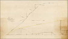
Included with the report is a fascinating map showing the locations of possible dams that could be used for the tailings. In addition, various types of workable gravel are shown. This topographic map shows the vicinity of Nevada City, Grass Valley, and Colfax, near Lake Tahoe. This is the same area where the infamous Malakoff Diggins, now a state park, were the catalyst for the banning of hydraulic mining.
![Nouvelle Carte Du Mexique, Du Texas Et D'Une Partie Des Etats Limitrophes . . . 1840 [Proposed Railroads In Texas -- First Appearance of Arizona on a Printed Map]](https://storage.googleapis.com/raremaps/img/small/103480.jpg)