


|
||

|

|
|

|
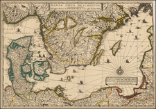
Second State of Seutter's map of Lithuania and Poland, extending from the Baltic (Riga) to Palatinat Polesia Bressicenis in the south.
A highly detailed map of Lithuania, showing towns, castles, Palatinates, rivers, lakes, forests, etc.
There are 3 states of the map:
- State 1: No privilege in the top right corner
- State 2: Seutter privilege added at top right (1731-32)
- State 3: JM Probst imprint added at the upper left corner (1762)
The map shows the region shortly after the concluion of the Great Northern War (1700-1721). During this time, the Russian army invaded Lithuania, causing significant damage to the country and weakening its power. The war ended with the Treaty of Nystad in 1721, which ceded parts of Lithuania to Russia and limited the political independence of the country.
Matthäus Seutter (1678-1757) was a prominent German mapmaker in the mid-eighteenth century. Initially apprenticed to a brewer, he trained as an engraver under Johann Baptist Homann in Nuremburg before setting up shop in his native Augsburg. In 1727 he was granted the title Imperial Geographer. His most famous work is Atlas Novus Sive Tabulae Geographicae, published in two volumes ca. 1730, although the majority of his maps are based on earlier work by other cartographers like the Homanns, Delisles, and de Fer.
Alternative spellings: Matthias Seutter, Mathaus Seutter, Matthaeus Seutter, Mattheus Seutter
![[Helsinki and Talinn] De Zeecusten van Lijflandt van Dageroort tot Revel en van Vinlandt daer tegen over](https://storage.googleapis.com/raremaps/img/small/75573.jpg)
![Europae Tabula VIII [Russia, Ukraine, Baltic, Scandinavia]](https://storage.googleapis.com/raremaps/img/small/86526.jpg)