The item illustrated and described below is sold, but we
have another example in stock. To view the example which
is currently being offered for sale, click the
"View Details" button below.

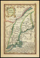
1792 John Stockdale / Jedidiah Morse
$ 575.00


|
||

|

|
|

|
Stock# 63430
Description
Stockdale's map of the Northern and Mid-Atlantic states, published in 1792.
The map is most notable for the many land grants showing Western Territory, which then included Ohio, Tennessee and the Old Northwest Territory. The grants include Illinois Company, Army Lands, Wagbash Company, New Jersey Company, Ohio Company, and the 7 Ranges, along with the Donation Lands from the Commonwealth of Virginia and General Clark's Grant 1500 acres.
Many settlements are noted in the West, along with early forts (Miami, Pitt, Venango, Chartres) and other interesting features. St. Louis appears on the map, as does Louisville, St. Genevieve, New Madrid, St. Philips, Cahokia, and the Kaskaskia Village.
A nice post-revolutionary war map of the region.
Condition Description
Some modern tape on several folds. Backed with paper in the 20th Century. Normally a $700 map.
![[ Atlas - Florida and Southern Canal Projects ] Travaux d'améliorations intérieurs projetés ou exécutés par le gouvernement général des États-Unis d'Amérique, de 1824 à 1831 [complete with:] Travaux d'améliorations intérieurs projetés ou exécutés... Atlas.](https://storage.googleapis.com/raremaps/img/small/85067.jpg)

![Carte Du Canada ou de la Nouvelle France et des Decouvertes qui y ont ete faites . . . [Map of Canada or New France and the Discoveries Made Therein . . .]](https://storage.googleapis.com/raremaps/img/small/94450.jpg)