|
||

|

|
|

|
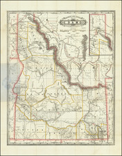
Early Cadastral Map of Boise Idaho
Rare separately published map of Boise, published by the Inter-Mountain Map Co. The map is remarkably predictive of the path of growth and open space in modern Boise.
Detailed map of Boise, Idaho, filled with the names of early land owners, ranchers and "Botton Land". The lands of Boise Arteslan Hot & Cold Water Company is also shown in the northeast, along with the Fort Boise Military Reservation and Barracks.
The map unfolds on either side of the Boise River, showing the results of two different overlapping grid systems, with the City of South Boise shown. West of the River are a number of Subdivisions, but it is east of the River where the Additions and Subdivisions flourish, including:
- Original Boise Townsite (with Capitol and Court House)
- Fairview Addition
- Pleasanton Addition
- Frank Davis Addition
- Hubble Home Addition
- Cruzen Addition
- Highland Park Addition
- Lemp Addition
- Ellis Addition
- Packenham Addition
- Elm Grove Addition
- North Lucust Grove Addition
- Locust Grove Addition
- Brumback Addition
- Vaughn Addition
- Hyde Park Addition
- Bryon Addition
- 3 different Krall Additions
- East Side Addition
- Delamar Addition
- Warm Springs Addition
- Denver Addition
In the year the map was published the first phase of the Idaho State Capitol building was just opening and the population of Boise was about 17,500 people and had tripled since 1900.
Includes a list of other maps by Inter-Mountain on the verso,
Charles Werts
Werts applied for copyrights for a map of Ada County in 1910 and a much larger map of Boise in 1909, but this map is not listed in the Copyright books we found and we locate no institutional copies.
Frank W. Almond and Chester Werts seem to have worked together as Inter-Mountain in the period between about 1909 and 1917, issuing several maps of Boise and Ada County, all of which are extremely rare, with the only examples recorded by OCLC in the Idaho State Archives (1909, 1912, 1915, 1916 and 1917) and Boise State University (1909).
Rarity
OCLC locates a single copy of the map (Idaho State Archives).
Werts applied for copyrights for a map of Ada County in 1910 and a much larger map of Boise in 1909, but this map is not listed in the Copyright books we found and we locate no institutional copies.
![[Report and] Map of an Exploring Expedition to The Rocky Mountains in the Years 1842 and to Oregon & North California in the Years 1843-44 By Brevet Capt. J. C. Fremont of the Corps of Topographical Engineers . . .](https://storage.googleapis.com/raremaps/img/small/88488.jpg)
![[ Sun Valley Ski Map ]](https://storage.googleapis.com/raremaps/img/small/101431.jpg)